IMAGES TAKEN NEAR TO
Burnside Road, JOHNSTONE, PA5 9JU
Introduction
This page details the photographs taken nearby to Burnside Road, PA5 9JU by members of the Geograph project.
The Geograph project started in 2005 with the aim of publishing, organising and preserving representative images for every square kilometre of Great Britain, Ireland and the Isle of Man.

There are currently over 7.5m images from over14,400 individuals and you can help contribute to the project by visiting https://www.geograph.org.uk
Image Map
Images are licensed for reuse under creativecommons.org/licenses/by-sa/2.0
Notes
- Clicking on the map will re-center to the selected point.
- The higher the marker number, the further away the image location is from the centre of the postcode.
Image Listing (44 Images Found)
Images are licensed for reuse under creativecommons.org/licenses/by-sa/2.0
Image
Details
Distance
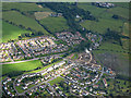
1
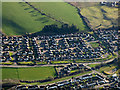
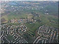
Elderslie from the air
Glenpatrick Road is prominent.
Image: © Thomas Nugent
Taken: 28 Jan 2019
0.03 miles
2
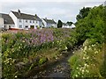
Old Patrick Water
The view is from a bridge which carries Abbey Road over the Old Patrick Water: Image
The burn is known colloquially as the Brandy Burn, because of the industry that sprang up alongside it in recent centuries.
The Blaeu map (1654) of "The Baronie of Renfrow" shows it as the "Ald Patrick b." (burn). "Altpatrick", the old form, probably contains the Gaelic "allt" (burn, stream, water), later reinterpreted as "auld", and hence "old". The original sense of "allt" as "water" was lost, and "Water" was tagged on to the modern name.
Image: © Lairich Rig
Taken: 22 Jul 2013
0.03 miles
3
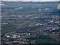
Glasgow Airport from the air
Elderslie is in the left foreground, Paisley and Renfrew on the right, Clydebank and Dalmuir in the distance on the far side of the River Clyde. Note the rivers each side of the airport - Black Cart on the left, White Cart on the right, joining just beyond the airport to be come the River Cart before joining the Clyde. Viewed from a Prague bound flight which has just taken off from the airport.
Image: © Thomas Nugent
Taken: 11 Feb 2019
0.04 miles
4
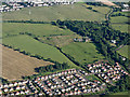
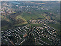
Elderslie from the air
A housing estate off Glenpatrick Road. Leitchland Farm and part of Foxbar in Paisley are also visible.
Image: © Thomas Nugent
Taken: 19 Jul 2015
0.04 miles
5
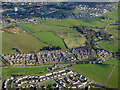
Elderslie and Paisley from the air
Abbey Cemetery is in the foreground. Stanely reservoir and castle are in the distance.
Image: © Thomas Nugent
Taken: 18 Mar 2015
0.04 miles
6
Elderslie from the air
Old Patrick Water can be seen near the centre of the photo.
Image: © Thomas Nugent
Taken: 18 Mar 2015
0.04 miles
7
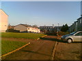
Houston square, Elderslie
This photograph shows the end of Houston square and a path leading down to Barclay Avenue. At the bottom of the path is where the old Elderslie chapel used to be Houses are currently being built on the spot.
Image: © Richard Kelly
Taken: 4 Apr 2006
0.04 miles
8
Building site on Abbey Road from the air
Looking over Glenpatrick Road, with Foxbar in the distance.
Image: © Thomas Nugent
Taken: 17 Apr 2017
0.05 miles
9
Bridge over Old Patrick Water
The bridge carries Abbey Road over the Image The picture was taken from near the junction with Glenpatrick Road (the area's name, Glenpatrick, is another commemoration of the saint).
Image: © Lairich Rig
Taken: 22 Jul 2013
0.07 miles
10
Elderslie from the air
Glenpatrick road is the main thoroughfare seen here.
Image: © Thomas Nugent
Taken: 7 Aug 2017
0.08 miles