IMAGES TAKEN NEAR TO
Newfield Way, JOHNSTONE, PA5 8WJ
Introduction
This page details the photographs taken nearby to Newfield Way, PA5 8WJ by members of the Geograph project.
The Geograph project started in 2005 with the aim of publishing, organising and preserving representative images for every square kilometre of Great Britain, Ireland and the Isle of Man.

There are currently over 7.5m images from over14,400 individuals and you can help contribute to the project by visiting https://www.geograph.org.uk
Image Map
Images are licensed for reuse under creativecommons.org/licenses/by-sa/2.0
Notes
- Clicking on the map will re-center to the selected point.
- The higher the marker number, the further away the image location is from the centre of the postcode.
Image Listing (22 Images Found)
Images are licensed for reuse under creativecommons.org/licenses/by-sa/2.0
Image
Details
Distance
1
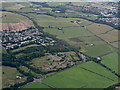
Site of Merchiston Hospital from the air
The mental hospital was on the edge of the village of Brookfield. It was demolished in 2013.
Image: © Thomas Nugent
Taken: 3 Aug 2015
0.06 miles
2
Duddon Sands from the air
Kirkby-in-Furness is in the lower left corner. The Irish Sea coast can be seen near the top of the photo.
Image: © Thomas Nugent
Taken: 3 Aug 2015
0.06 miles
3
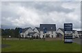
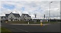
Housing development at Brookfield
On the site of the former Merchiston Hospital at the junction of the A761 and B789 roads between Brookfield, Linwood and Johnstone.
Image: © Thomas Nugent
Taken: 1 May 2020
0.08 miles
4
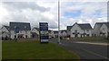
Housing development at Brookfield
On the site of the former Merchiston Hospital at the junction of the A761 and B789 roads between Brookfield, Linwood and Johnstone.
Image: © Thomas Nugent
Taken: 1 May 2020
0.08 miles
5
Housing development at Brookfield
On the site of the former Merchiston Hospital at the junction of the A761 and B789 roads between Brookfield, Linwood and Johnstone.
Image: © Thomas Nugent
Taken: 1 May 2020
0.08 miles
7
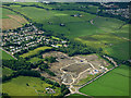
Site of Merchiston Hospital from the air
Now in the early stages of construction of a housing estate.
See the scene in 2015 Image
See the scene in 2012, before demolition Image
Image: © Thomas Nugent
Taken: 19 Jun 2017
0.12 miles
8
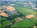
Brookfield from the air
The site of the former Merchiston Hospital is in the foreground.
Image: © Thomas Nugent
Taken: 30 Aug 2016
0.14 miles
9
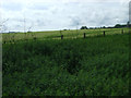
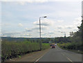
Field near Linwood
Between East Fulton and the Brookfield roundabout. Viewed from the cycle path.
Image: © Thomas Nugent
Taken: 14 Jun 2013
0.17 miles
10

Site of Houston & Crosslee station, 1997
View northward, towards Kilmacolm and Greenock Princes Pier: ex-G&SWR Glasgow St Enoch - Paisley - Greenock Princes Pier line. Named plain 'Houston' from 7/5/73, the station was closed on 10/1/83 when the remnant of the Princes Pier line from Elderslie was closed; the Kilmacolm - Princes Pier section had closed 2/2/59 although Boat trains continued until 20/11/65.
Image: © Ben Brooksbank
Taken: 30 Jun 1997
0.18 miles