IMAGES TAKEN NEAR TO
Stanley Drive, JOHNSTONE, PA5 8UF
Introduction
This page details the photographs taken nearby to Stanley Drive, PA5 8UF by members of the Geograph project.
The Geograph project started in 2005 with the aim of publishing, organising and preserving representative images for every square kilometre of Great Britain, Ireland and the Isle of Man.

There are currently over 7.5m images from over14,400 individuals and you can help contribute to the project by visiting https://www.geograph.org.uk
Image Map
Images are licensed for reuse under creativecommons.org/licenses/by-sa/2.0
Notes
- Clicking on the map will re-center to the selected point.
- The higher the marker number, the further away the image location is from the centre of the postcode.
Image Listing (10 Images Found)
Images are licensed for reuse under creativecommons.org/licenses/by-sa/2.0
Image
Details
Distance
1
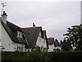
Black & White
Brookfield Village houses Renfrewshire.
Image: © Chris Court
Taken: 5 Oct 2005
0.14 miles
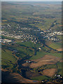
2
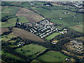
Brookfield from the air
The site of Merchiston Hospital is to the lower right.
Image: © Thomas Nugent
Taken: 16 Feb 2015
0.14 miles
3
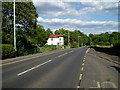
Bridge of Weir Road
A761 at Brookfield.
Image: © Gordon Dowie
Taken: 25 May 2010
0.16 miles
4
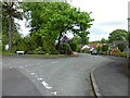
The Beeches
Residential street in Brookfield, Renfrewshire.
Image: © Stephen Sweeney
Taken: 11 May 2011
0.18 miles
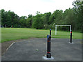
5
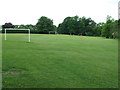
Village Park
On Woodside Road, Brookfield.
Image: © Thomas Nugent
Taken: 14 Jun 2013
0.22 miles
6
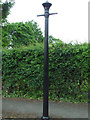
Old gas lamppost
On Woodside Road, Brookfield.
Image: © Thomas Nugent
Taken: 14 Jun 2013
0.24 miles
7
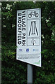
Village Park sign
On Woodside Road, Brookfield. The cycle logo refers to the adjacent National Cycle Network Route 75.
Image: © Thomas Nugent
Taken: 14 Jun 2013
0.24 miles
8
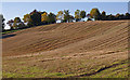
Stubble Field, Brookfield
Cemetery on the hill top.
Image: © wfmillar
Taken: 11 Oct 2010
0.24 miles
9
Village Park
Bollards at the entrance to National Cycle Network Route 75 on Woodside Road.
Image: © Thomas Nugent
Taken: 14 Jun 2013
0.24 miles
10
Bridge of Weir from the air
Brookfield cemetery is in the foreground, where the A761 Bridge of Weir Road can be seen heading to and through Bridge of Weir on its way to Port Glasgow. Quarriers Village is in the centre of the photo.
Image: © Thomas Nugent
Taken: 9 Dec 2019
0.25 miles