IMAGES TAKEN NEAR TO
Bevan Grove, JOHNSTONE, PA5 8TP
Introduction
This page details the photographs taken nearby to Bevan Grove, PA5 8TP by members of the Geograph project.
The Geograph project started in 2005 with the aim of publishing, organising and preserving representative images for every square kilometre of Great Britain, Ireland and the Isle of Man.

There are currently over 7.5m images from over14,400 individuals and you can help contribute to the project by visiting https://www.geograph.org.uk
Image Map
Images are licensed for reuse under creativecommons.org/licenses/by-sa/2.0
Notes
- Clicking on the map will re-center to the selected point.
- The higher the marker number, the further away the image location is from the centre of the postcode.
Image Listing (20 Images Found)
Images are licensed for reuse under creativecommons.org/licenses/by-sa/2.0
Image
Details
Distance
1
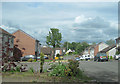
Bevan Grove western end
From very end of road
Image: © John Firth
Taken: 11 May 2011
0.01 miles
2
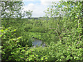
River through the tree
From garden at the very west end of Bevan Grove
Image: © John Firth
Taken: 11 May 2011
0.09 miles
3
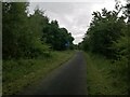
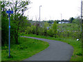
Cycle tracks meet
The track from Millikenpark here meets the main National Cycle Route 7. Straight ahead for Johnstone then Paisley, or left at the sign for Lochwinnoch and points south and west.
Image: © Alec MacKinnon
Taken: 28 Jun 2023
0.11 miles
4
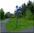
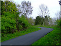
National Cycle Network Route 7
A junction in the path where it crosses the A737 road.
Image: © Thomas Nugent
Taken: 29 Apr 2011
0.12 miles
5
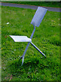
National Cycle Network Route 7
One of a pair of cleverly sculptured chairs in the form of two shovels.
Image: © Thomas Nugent
Taken: 29 Apr 2011
0.13 miles
6
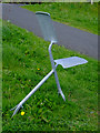
National Cycle Network Route 7
One of a pair of cleverly sculptured chairs in the form of two shovels. See also Image
Image: © Thomas Nugent
Taken: 29 Apr 2011
0.13 miles
7
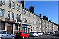
The Hagg Bar, Graham Street, Johnstone
Image: © Leslie Barrie
Taken: 25 Aug 2013
0.13 miles
8
National Cycle Network Route 7
The ramp up to the bridge over the A737.
Image: © Thomas Nugent
Taken: 29 Apr 2011
0.13 miles
9
National Cycle Network Route 7
The A737 road can be seen in the background.
Image: © Thomas Nugent
Taken: 29 Apr 2011
0.15 miles
10
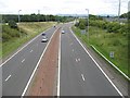
A737
A rather apt number to a road that runs to Glasgow Airport. The Johnstone bypass, with a lane closure.
Image: © Richard Webb
Taken: 13 Aug 2009
0.15 miles