IMAGES TAKEN NEAR TO
Miller Street, JOHNSTONE, PA5 8HW
Introduction
This page details the photographs taken nearby to Miller Street, PA5 8HW by members of the Geograph project.
The Geograph project started in 2005 with the aim of publishing, organising and preserving representative images for every square kilometre of Great Britain, Ireland and the Isle of Man.

There are currently over 7.5m images from over14,400 individuals and you can help contribute to the project by visiting https://www.geograph.org.uk
Image Map
Images are licensed for reuse under creativecommons.org/licenses/by-sa/2.0
Notes
- Clicking on the map will re-center to the selected point.
- The higher the marker number, the further away the image location is from the centre of the postcode.
Image Listing (31 Images Found)
Images are licensed for reuse under creativecommons.org/licenses/by-sa/2.0
Image
Details
Distance
1
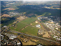
The A737 road from the air
Linwood is on the right, Morrisons supermarket with the big 'M' on the roof is at Johnstone. Brookfield, Crosslee, Houston and Bridge of Weir are scattered beyond.
Image: © Thomas Nugent
Taken: 20 Mar 2016
0.09 miles
2
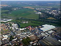
Johnstone from the air
The area between High Street and the A737 dual carriageway is home to many large sheds. Viewed from a flight from Luton on final approach to Glasgow from the southwest.
Image: © Thomas Nugent
Taken: 4 Sep 2010
0.09 miles
3
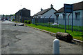
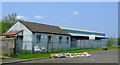
Miller Street
Johnstone Wheelers clubhouse is on the right Image
Image: © Thomas Nugent
Taken: 29 Apr 2011
0.10 miles
4
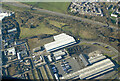
Johnstone from the air
Malcolm Logistics occupies most of the buildings and yards in this industrial part of Johnstone. A large stack of wooden barrels can be seen to the right of centre.
Malcolm Logistics: https://www.malcolmgroup.co.uk/logistics .
Image: © Thomas Nugent
Taken: 6 Mar 2022
0.12 miles
5
Johnstone Wheelers clubhouse
Johnstone Wheelers is one of the oldest and largest cycling clubs in Scotland. The clubhouse is on Miller Street, opposite the playing fields.
Image: © Thomas Nugent
Taken: 29 Apr 2011
0.12 miles
6
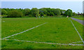
King George V playing fields
On Miller Street.
Image: © Thomas Nugent
Taken: 29 Apr 2011
0.13 miles
8
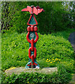
Cycle route marker
On Route 7 of the National Cycle Network, just off Miller Street.
Image: © Thomas Nugent
Taken: 29 Apr 2011
0.21 miles
9
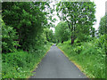
Cycle path at Elderslie
Approaching Johnstone on National Cycle Network Route 7. One of WH Malcolm's large transport depots and yards is behind the bushes on the right.
Image: © Thomas Nugent
Taken: 14 Jun 2013
0.21 miles
10
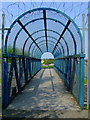
Secure bridge
This bridge carries Route 7 of the National Cycle Network over a new private road which links different parts of the Malcolm Logistics campus which dominates the area.
Image: © Thomas Nugent
Taken: 29 Apr 2011
0.21 miles