IMAGES TAKEN NEAR TO
Craigdonald Place, JOHNSTONE, PA5 8EH
Introduction
This page details the photographs taken nearby to Craigdonald Place, PA5 8EH by members of the Geograph project.
The Geograph project started in 2005 with the aim of publishing, organising and preserving representative images for every square kilometre of Great Britain, Ireland and the Isle of Man.

There are currently over 7.5m images from over14,400 individuals and you can help contribute to the project by visiting https://www.geograph.org.uk
Image Map
Images are licensed for reuse under creativecommons.org/licenses/by-sa/2.0
Notes
- Clicking on the map will re-center to the selected point.
- The higher the marker number, the further away the image location is from the centre of the postcode.
Image Listing (55 Images Found)
Images are licensed for reuse under creativecommons.org/licenses/by-sa/2.0
Image
Details
Distance
1
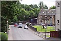
Dimity Street looking towards junction with Campbell St, Johnstone
Image: © Vince Madden
Taken: 13 Jul 2006
0.04 miles
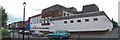
3
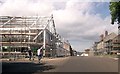
New council buildings under construction
Image: © John Firth
Taken: 16 May 2014
0.05 miles
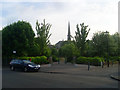
6
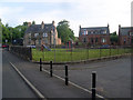
Playpark in Johnstone
Sandwiched between Quarry Street and Dimity Street.
Image: © Stephen Sweeney
Taken: 3 Jun 2010
0.06 miles
7
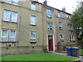
Apartments at 14 Dimity Street.
Although not the buildings that were here in the 1800's, the address is the same, 14 Dimity Street, as when my great grand parents lived there.
Image: © Joe Hay
Taken: 21 Jul 2011
0.07 miles
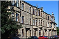
8
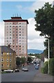
Tower Block at the corner of High Street and Dimity Street, Johnstone
Image: © Vince Madden
Taken: 4 Jul 2006
0.08 miles
9
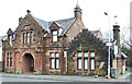
Dimity Street drill hall
Described by Canmore http://canmore.rcahms.gov.uk/en/site/317133/details/johnstone+dimity+street+35+johnstone+drill+hall+former/ as follows...
"The Dimity Street drill hall is marked on the 2nd and 3rd epoch maps (surveyed in 1895 and 1911 respectively). There is a two-storey, three-bay front block with a crow-stepped gable over a large arched doorway, with dormers on both sides. There is a single-storey annex to the SE and the hall, now demolished and replaced by a dwelling, was behind.
Information from HS/RCAHMS World War One Audit Project (GJB) 24 October 2013.".
See also Image & Image
Image: © Thomas Nugent
Taken: 18 Mar 2015
0.08 miles
10
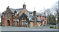
Dimity Street drill hall
Described by Canmore http://canmore.rcahms.gov.uk/en/site/317133/details/johnstone+dimity+street+35+johnstone+drill+hall+former/ as follows...
"The Dimity Street drill hall is marked on the 2nd and 3rd epoch maps (surveyed in 1895 and 1911 respectively). There is a two-storey, three-bay front block with a crow-stepped gable over a large arched doorway, with dormers on both sides. There is a single-storey annex to the SE and the hall, now demolished and replaced by a dwelling, was behind.
Information from HS/RCAHMS World War One Audit Project (GJB) 24 October 2013.".
See also Image & Image
Image: © Thomas Nugent
Taken: 18 Mar 2015
0.08 miles