IMAGES TAKEN NEAR TO
Laighcartside Street, JOHNSTONE, PA5 8DB
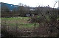
Introduction
This page details the photographs taken nearby to Laighcartside Street, PA5 8DB by members of the Geograph project.
The Geograph project started in 2005 with the aim of publishing, organising and preserving representative images for every square kilometre of Great Britain, Ireland and the Isle of Man.

There are currently over 7.5m images from over14,400 individuals and you can help contribute to the project by visiting https://www.geograph.org.uk
Image Map
Images are licensed for reuse under creativecommons.org/licenses/by-sa/2.0
Notes
- Clicking on the map will re-center to the selected point.
- The higher the marker number, the further away the image location is from the centre of the postcode.
Image Listing (33 Images Found)
Images are licensed for reuse under creativecommons.org/licenses/by-sa/2.0
Image
Details
Distance
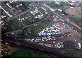
1
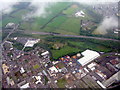
The A737 at Elderslie
An aerial view, with a Morrisons store on the left ['M' on the roof], the Black Cart Water passing by, and the remains of two gas holders by the large building near the centre.
Image: © M J Richardson
Taken: 26 Sep 2015
0.02 miles
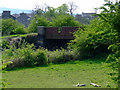
2
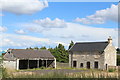
Barbush Farm, Johnstone
Only the farmhouse and one shed remain standing
Image: © Leslie Barrie
Taken: 6 Jul 2014
0.16 miles
3
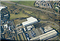
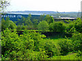
Johnstone from the air
Malcolm Logistics occupies most of the buildings and yards in this industrial part of Johnstone. A large stack of wooden barrels can be seen to the right of centre.
Malcolm Logistics: https://www.malcolmgroup.co.uk/logistics .
Image: © Thomas Nugent
Taken: 6 Mar 2022
0.16 miles
5
Disused railway bridge over Black Cart Water
Image: © Alan Reid
Taken: 15 Jan 2020
0.17 miles
6
Former Lochwinnoch Loop railway line
Viewed from Route 7 of the National Cycle Network.
Image: © Thomas Nugent
Taken: 29 Apr 2011
0.17 miles
7
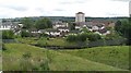
Johnstone
Looking into the town from a disused railway near what is now a supermarket.
Image: © Richard Webb
Taken: 13 Aug 2009
0.17 miles
8

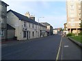
Thorn Brae
Looking down the hill towards High Street.
Image: © Thomas Nugent
Taken: 21 Aug 2010
0.18 miles
10
Former Lochwinnoch Loop railway line
Viewed from Route 7 of the National Cycle Network.
Image: © Thomas Nugent
Taken: 29 Apr 2011
0.19 miles