IMAGES TAKEN NEAR TO
Rankine Street, JOHNSTONE, PA5 8BA
Introduction
This page details the photographs taken nearby to Rankine Street, PA5 8BA by members of the Geograph project.
The Geograph project started in 2005 with the aim of publishing, organising and preserving representative images for every square kilometre of Great Britain, Ireland and the Isle of Man.

There are currently over 7.5m images from over14,400 individuals and you can help contribute to the project by visiting https://www.geograph.org.uk
Image Map
Images are licensed for reuse under creativecommons.org/licenses/by-sa/2.0
Notes
- Clicking on the map will re-center to the selected point.
- The higher the marker number, the further away the image location is from the centre of the postcode.
Image Listing (56 Images Found)
Images are licensed for reuse under creativecommons.org/licenses/by-sa/2.0
Image
Details
Distance
1
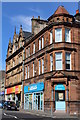
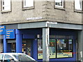
Corner of High Street & Rankine Street, Johnstone
Image: © Leslie Barrie
Taken: 25 Aug 2013
0.06 miles
2
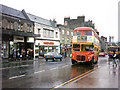
Johnstone High Street
Johnstone High Street, the site of one of the now-closed branches of Woolworth's, on a rainy day in April 1989. A Routemaster bus has just arrived from Glasgow.
Image: © David Roberts
Taken: 13 Apr 1989
0.08 miles
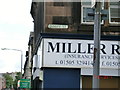
3
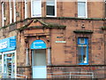
Corner building at High and Rankine streets
As I walk up High Street to the High Parish Church, taking photos of streets where my ancestors lived in the 1800's.
Image: © Joe Hay
Taken: 21 Jul 2011
0.08 miles
5
Building at corner of Walkinshaw and High Streets
Several of my ancestors lived on Walkinshaw Street.
Image: © Joe Hay
Taken: 21 Jul 2011
0.09 miles
6
Street corner at High and Dimity Streets.
Taking photos of streets where my ancestors lived in the 1800's as I walk up High Street to the High Parish Church.
Image: © Joe Hay
Taken: 21 Jul 2011
0.09 miles
7

Masonic Hall Johnstone
Masonic Hall on Collier Street Johnstone. 26th July 2009 8.25p.m.
Image: © Gordon Dowie
Taken: 26 Jul 2009
0.09 miles
8
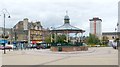
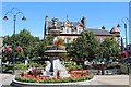
Houston Square, Johnstone
For another view (and for details of the tower block in the background), see Image
The bandstand is also shown in Image, and is by James B. Lamb (1891). For further details, see its listed building report, http://portal.historic-scotland.gov.uk/designation/LB35615 (at Historic Environment Scotland); see also https://canmore.org.uk/site/195969/johnstone-houston-square-general (at Canmore) for further pictures.
Image: © Lairich Rig
Taken: 22 Aug 2011
0.10 miles
9
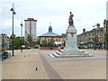
Houston Square, Johnstone
This view of Johnstone's town centre shows the war memorial – Image – and a bandstand; for the latter, see Image and Image
The tower block in the background is Johnstone's tallest building, Provost Close; see http://www.geograph.org.uk/photo/927970 and http://www.geograph.org.uk/photo/931128 for other views of it.
Image: © Lairich Rig
Taken: 22 Aug 2011
0.10 miles
10
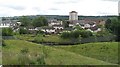
Johnstone
Looking into the town from a disused railway near what is now a supermarket.
Image: © Richard Webb
Taken: 13 Aug 2009
0.10 miles