IMAGES TAKEN NEAR TO
Greenend Avenue, JOHNSTONE, PA5 0LF
Introduction
This page details the photographs taken nearby to Greenend Avenue, PA5 0LF by members of the Geograph project.
The Geograph project started in 2005 with the aim of publishing, organising and preserving representative images for every square kilometre of Great Britain, Ireland and the Isle of Man.

There are currently over 7.5m images from over14,400 individuals and you can help contribute to the project by visiting https://www.geograph.org.uk
Image Map
Images are licensed for reuse under creativecommons.org/licenses/by-sa/2.0
Notes
- Clicking on the map will re-center to the selected point.
- The higher the marker number, the further away the image location is from the centre of the postcode.
Image Listing (17 Images Found)
Images are licensed for reuse under creativecommons.org/licenses/by-sa/2.0
Image
Details
Distance
2
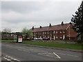
Craigview Avenue
Parallel to Beith Road, Johnstone.
Image: © Richard Webb
Taken: 25 Apr 2014
0.14 miles
3

Craigview Terrace, Milliken Park
Quite interesting example of terraced architecture - not too commonly seen round the Greater Glasgow area.
Image: © Stephen Sweeney
Taken: 11 May 2011
0.14 miles
4
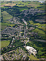
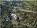
Kilbarchan from the air
Cartside Mill is at the bottom of the photo, the A737 road runs horizontaly beyond, with the line of the former Lochwinnoch Loop railway line marked by a line of trees and the blue bridge near the centre. Easwald Bank is the main road seen running vertically.
See also Image
Image: © Thomas Nugent
Taken: 19 Jun 2017
0.15 miles
5
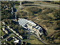
Cartside Mill from the air
Just off the A737 road. See also Image Home to Smith and McLaurin, ticket, tag and self-adhesive label material manufacturer since 1849.
Web site: https://www.smcl.co.uk/ .
Image: © Thomas Nugent
Taken: 6 Mar 2022
0.15 miles
6
Johnstone from the air
Cartside Mill Image is prominent.
Image: © Thomas Nugent
Taken: 6 Mar 2022
0.15 miles
7
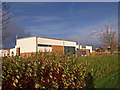
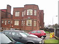
School, Milikenpark, Johnstone
Beside the Beith Road.
Image: © wfmillar
Taken: 27 Nov 2009
0.19 miles
8
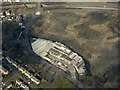
Cartside Mill from the air
By Black Cart Water between Johnstone and Kilbarchan. Producing labels, tickets and tags since 1849 http://www.smcl.co.uk/ .
Image: © Thomas Nugent
Taken: 20 Mar 2016
0.19 miles
9
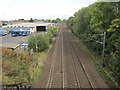
Milliken Park 1st railway station (site), Renfrewshire
Opened in 1846 as "Cochrane Mill" by the Glasgow, Paisley, Kilmarnock & Ayr Railway, later part of the Glasgow & South Western Railway, this station was renamed "Cochranemill in 1851 before becoming "Milliken Park" in 1853. It closed in 1966.
View north east towards Johnstone and Glasgow. In 1989, British Rail opened a replacement station immediately behind the camera position. See Image
Image: © Nigel Thompson
Taken: 4 Oct 2013
0.19 miles
10
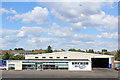
McGill's Johnstone Depot
Bus depot on Cochranemill Road
Image: © Leslie Barrie
Taken: 10 Jul 2014
0.19 miles