IMAGES TAKEN NEAR TO
Sycamore Avenue, JOHNSTONE, PA5 0BN
Introduction
This page details the photographs taken nearby to Sycamore Avenue, PA5 0BN by members of the Geograph project.
The Geograph project started in 2005 with the aim of publishing, organising and preserving representative images for every square kilometre of Great Britain, Ireland and the Isle of Man.

There are currently over 7.5m images from over14,400 individuals and you can help contribute to the project by visiting https://www.geograph.org.uk
Image Map
Images are licensed for reuse under creativecommons.org/licenses/by-sa/2.0
Notes
- Clicking on the map will re-center to the selected point.
- The higher the marker number, the further away the image location is from the centre of the postcode.
Image Listing (25 Images Found)
Images are licensed for reuse under creativecommons.org/licenses/by-sa/2.0
Image
Details
Distance
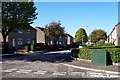
1

Junction of Willow Drive and Hawthorn Avenue, Johnstone
March 1st 2018 - 'The Beast from the East'
Image: © Vince Madden
Taken: 1 Mar 2018
0.13 miles
3
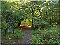
Housing estate, Johnstone
The southern edge of the town - a series of streets with a tree-name theme, and Craigston Wood beyond.
Image: © M J Richardson
Taken: 11 May 2016
0.15 miles
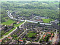
4
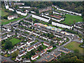
Johnstone Castle from the air
This area of Johnstone takes its name from the nearby Johnstone Castle Image Major redevelopment appears to be in progress.
Johnstone Castle Learning Centre on Pine Crescent is in the foreground, with Alder Place beyond. Houses construction us in progress on Elm Drive, with Auchenlodment Primary School beyond. The houses at top left are in Elderslie.
Image: © Thomas Nugent
Taken: 4 Oct 2019
0.18 miles
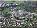
5
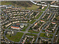
Johnstone Castle from the air
This area of Johnstone takes its name from the nearby Johnstone Castle Image Major redevelopment appears to be in progress.
Johnstone Castle Learning Centre on Pine Crescent is in the foreground, with Alder Place beyond. Houses construction us in progress on Elm Drive, with Auchenlodment Primary School beyond.
Image: © Thomas Nugent
Taken: 4 Oct 2019
0.18 miles
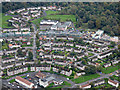
7
Johnstone Castle from the air
This area of Johnstone takes its name from the nearby Johnstone Castle Image Major redevelopment appears to be in progress.
Image: © Thomas Nugent
Taken: 4 Oct 2019
0.19 miles
8
Johnstone Castle from the air
The Category B Listed castle http://portal.historic-scotland.gov.uk/designation/LB35602 is now surrounded by council houses.
See also Image
Image: © Thomas Nugent
Taken: 16 Mar 2016
0.20 miles
9
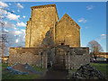
Johnstone Castle
South elevation showing some of the seemingly abandoned building works.
Image: © wfmillar
Taken: 3 Feb 2009
0.20 miles
10
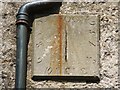
Sundial on Johnstone Castle
The setting is rather spoiled by the adjacent pipe (whose run-off has also stained it), but this sundial, dated 1700, is still of interest. It is fixed high on the south-facing wall of Image Its location can be picked out, on the right, in Image
This is a vertical direct south dial (see Image), but it has lost its gnomon.
Image: © Lairich Rig
Taken: 11 Jul 2011
0.20 miles