IMAGES TAKEN NEAR TO
Greenhead Road, RENFREW, PA4 9QY
Introduction
This page details the photographs taken nearby to Greenhead Road, PA4 9QY by members of the Geograph project.
The Geograph project started in 2005 with the aim of publishing, organising and preserving representative images for every square kilometre of Great Britain, Ireland and the Isle of Man.

There are currently over 7.5m images from over14,400 individuals and you can help contribute to the project by visiting https://www.geograph.org.uk
Image Map
Images are licensed for reuse under creativecommons.org/licenses/by-sa/2.0
Notes
- Clicking on the map will re-center to the selected point.
- The higher the marker number, the further away the image location is from the centre of the postcode.
Image Listing (43 Images Found)
Images are licensed for reuse under creativecommons.org/licenses/by-sa/2.0
Image
Details
Distance
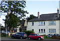
1
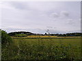
Looking to Inchinnan from Greenock Road A8
Across the field to the north of the road.
Image: © Stephen Sweeney
Taken: 21 Jul 2007
0.04 miles
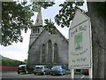
3
Former Park Parish Church
On Luckinsford Road. Category B Listed
http://portal.historicenvironment.scot/designation/LB12731 .
Image: © Thomas Nugent
Taken: 25 Aug 2018
0.10 miles
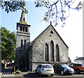
4
Former Park Parish Church
On Luckinsford Road. Category B Listed
http://portal.historicenvironment.scot/designation/LB12731 .
Image: © Thomas Nugent
Taken: 25 Aug 2018
0.10 miles
5
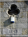
Former Park Parish Church
The 1849 date stone and trefoil window on the front of the Category B Listed building on Luckingsford Road http://portal.historicenvironment.scot/designation/LB12731 .
Image: © Thomas Nugent
Taken: 25 Aug 2018
0.10 miles
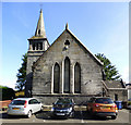
6
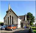
Former Park Parish Church
On Luckinsford Road. Category B Listed
http://portal.historicenvironment.scot/designation/LB12731 .
Image: © Thomas Nugent
Taken: 25 Aug 2018
0.10 miles
7
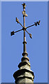
Former Park Parish Church weather vane
On the church tower on Luckinsford Road. Category B Listed
http://portal.historicenvironment.scot/designation/LB12731 .
Image: © Thomas Nugent
Taken: 25 Aug 2018
0.10 miles
8
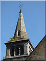
Former Park Parish Church spire
Described as a 'stumpy stone tower in the Category B Listing document http://portal.historicenvironment.scot/designation/LB12731 .
Image: © Thomas Nugent
Taken: 25 Aug 2018
0.10 miles
9
Luckinsford Road
The former Park Parish Church on the left is Category B Listed http://portal.historicenvironment.scot/designation/LB12731 .
Image: © Thomas Nugent
Taken: 25 Aug 2018
0.11 miles
10
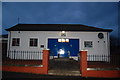
Masonic Lodge, Inchinnan, Renfrewshire, Scotland
Lodge Inchinnan No.1405 & The Lodge of Erskine No.1566, Inchinnan, Renfrewshire, Scotland.
Image: © Jim Campbell
Taken: 7 Dec 2008
0.11 miles