IMAGES TAKEN NEAR TO
Inchinnan Road, RENFREW, PA4 9AE
Introduction
This page details the photographs taken nearby to Inchinnan Road, PA4 9AE by members of the Geograph project.
The Geograph project started in 2005 with the aim of publishing, organising and preserving representative images for every square kilometre of Great Britain, Ireland and the Isle of Man.

There are currently over 7.5m images from over14,400 individuals and you can help contribute to the project by visiting https://www.geograph.org.uk
Image Map
Images are licensed for reuse under creativecommons.org/licenses/by-sa/2.0
Notes
- Clicking on the map will re-center to the selected point.
- The higher the marker number, the further away the image location is from the centre of the postcode.
Image Listing (47 Images Found)
Images are licensed for reuse under creativecommons.org/licenses/by-sa/2.0
Image
Details
Distance
1
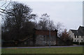
Former railway bridge
Carried the Renfrew District Line over North Lodge Road.
Image: © Thomas Nugent
Taken: 7 Feb 2010
0.05 miles
2
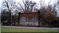
Former railway bridge
Carried the Renfrew District Line over North Lodge Road.
Image: © Thomas Nugent
Taken: 7 Feb 2010
0.06 miles
3
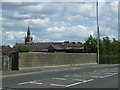
Former railway bridge
On Inchinnan Road. Crossed the Paisley - Renfrew Wharf line which closed in 1967. See also Image and Image
Image: © Thomas Nugent
Taken: 23 Jun 2008
0.06 miles
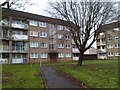
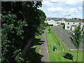
5
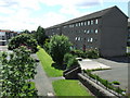
Rannoch Drive
Viewed from the old railway bridge on Inchinnan Road. The Paisley to Renfrew Wharf railway line (closed in 1967) once ran along the line of the footpath. See also Image and Image
Image: © Thomas Nugent
Taken: 23 Jun 2008
0.08 miles
6
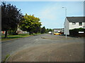
Craigielea Road, Renfrew
Looking northeast.
Image: © Richard Sutcliffe
Taken: 14 Aug 2022
0.09 miles
7

A golden car
Parked on Craigielea Road.
Image: © Richard Sutcliffe
Taken: 14 Aug 2022
0.09 miles
8
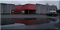
Former B & Q store
The store closed when a larger one opened at nearby Abbotsinch.
Image: © Thomas Nugent
Taken: 7 Feb 2010
0.11 miles
9
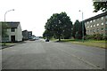
Craigielea Road, Renfrew
Looking southwest.
Image: © Richard Sutcliffe
Taken: 14 Aug 2022
0.12 miles
10
Fulbar Avenue
Viewed from the old railway bridge on Inchinnan Road. The Paisley to Renfrew Wharf railway line (closed in 1967) once ran along the line of the footpath. See also Image and Image
Image: © Thomas Nugent
Taken: 23 Jun 2008
0.13 miles