IMAGES TAKEN NEAR TO
Whimbrel Way, RENFREW, PA4 8SJ
Introduction
This page details the photographs taken nearby to Whimbrel Way, PA4 8SJ by members of the Geograph project.
The Geograph project started in 2005 with the aim of publishing, organising and preserving representative images for every square kilometre of Great Britain, Ireland and the Isle of Man.

There are currently over 7.5m images from over14,400 individuals and you can help contribute to the project by visiting https://www.geograph.org.uk
Image Map
Images are licensed for reuse under creativecommons.org/licenses/by-sa/2.0
Notes
- Clicking on the map will re-center to the selected point.
- The higher the marker number, the further away the image location is from the centre of the postcode.
Image Listing (123 Images Found)
Images are licensed for reuse under creativecommons.org/licenses/by-sa/2.0
Image
Details
Distance
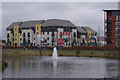
1
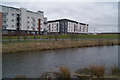
Pond in Clyde View Park
The new flats in the background are on Lapwing Road.
Image: © Thomas Nugent
Taken: 29 Mar 2010
0.05 miles
2
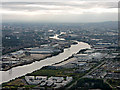
Renfrew and the Clyde from the air
Clyde View Park Image is in the foreground, the BAE Scotstoun shipyard and Braehead shopping centre are in the centre, Glasgow is in the distance.
Image: © Thomas Nugent
Taken: 14 Sep 2015
0.06 miles
3
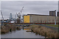
Pond in Clyde View Park
The sheds and cranes are at BAE's Scotstoun shipyard, on the opposite bank of the Clyde.
Image: © Thomas Nugent
Taken: 29 Mar 2010
0.07 miles
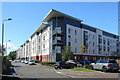
4
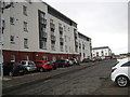
New flats on the King's Inch at Renfrew
The new estate is known as 'The Ferry Village'
Image: © James Denham
Taken: 16 Nov 2013
0.07 miles
5
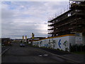
Ferry Village construction site
A new village being built between Renfrew and Braehead.
Image: © Stephen Sweeney
Taken: 20 Jun 2007
0.08 miles
6
Ferry Village, Renfrew
Part of the residential area located between Renfrew Ferry and Braehead.
Image: © Thomas Nugent
Taken: 20 Aug 2022
0.08 miles
7
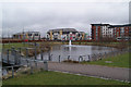
Clyde View Park
A brand new park at the heart of the housing developments along Kings Inch Road which can be seen in the background.
Image: © Thomas Nugent
Taken: 29 Mar 2010
0.08 miles
8
Pond in Clyde View Park
At the Kings Inch Road end of the park.
Image: © Thomas Nugent
Taken: 29 Mar 2010
0.08 miles
9
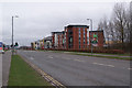
Kings Inch Road
Surrounded by housing developments on both sides of the road.
Image: © Thomas Nugent
Taken: 29 Mar 2010
0.08 miles
10
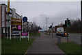
Kings Inch Road
The newly widened road between Renfrew and Braehead.
Image: © Thomas Nugent
Taken: 29 Mar 2010
0.09 miles