IMAGES TAKEN NEAR TO
Ferry Road, RENFREW, PA4 8SB
Introduction
This page details the photographs taken nearby to Ferry Road, PA4 8SB by members of the Geograph project.
The Geograph project started in 2005 with the aim of publishing, organising and preserving representative images for every square kilometre of Great Britain, Ireland and the Isle of Man.

There are currently over 7.5m images from over14,400 individuals and you can help contribute to the project by visiting https://www.geograph.org.uk
Image Map
Images are licensed for reuse under creativecommons.org/licenses/by-sa/2.0
Notes
- Clicking on the map will re-center to the selected point.
- The higher the marker number, the further away the image location is from the centre of the postcode.
Image Listing (177 Images Found)
Images are licensed for reuse under creativecommons.org/licenses/by-sa/2.0
Image
Details
Distance
2
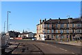
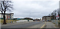
Meadowside Street
Viewed from Kings Inch Road, looking across Ferry Road.
Image: © Thomas Nugent
Taken: 29 Mar 2010
0.01 miles
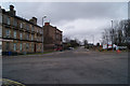
3
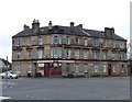
Renfrew tenements
On the corner of Ferry Road and Meadowside Street.
Image: © Stephen Sweeney
Taken: 26 Aug 2008
0.03 miles
4
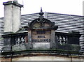
Neil Buildings Date Stone
See the entire building on Ferry Road here Image
Image: © Thomas Nugent
Taken: 26 Jan 2008
0.03 miles
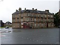
5
Neil Buildings
A corner tenement on Ferry Road at Meadwside Street, near Renfrew Ferry. See the date stone here Image
Image: © Thomas Nugent
Taken: 26 Jan 2008
0.04 miles
6
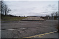
Flood prevention embankment
At Ferry Road, near Meadowside Street. Part of the North Renfrew Flood Prevention Scheme, Phase I.
Image: © Thomas Nugent
Taken: 29 Mar 2010
0.04 miles
7
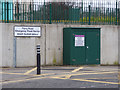
North Renfrew Flood Prevention Scheme
The pumping station is to the left of the concrete wall, which is closeable a gap in the defences to enable Ferry Road to operate normally during non flood conditions.
Image: © Thomas Nugent
Taken: 31 Mar 2018
0.04 miles
8
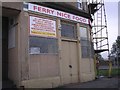
Ferry nice place to eat
Sandwich bar for Renfrew Ferry users.
Image: © Chris Upson
Taken: 30 Sep 2005
0.05 miles
9
Ferry Road emergency flood barrier
The pumping station of the North Renfrew Flood Prevention Scheme is behind the railings. The scheme aims to ensure that the area will have a 1 in 200 year level of flood protection from the combined risks of the Mill Burn overflowing and tidal surges from the River Clyde.
Image: © Thomas Nugent
Taken: 31 Mar 2018
0.05 miles
10
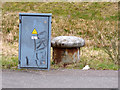
Old bollard on Ferry Road
The bollard is now remote from Ferry Dock which was partially filled as part of the North Renfrew Flood Prevention Scheme.
Image: © Thomas Nugent
Taken: 31 Mar 2018
0.06 miles