IMAGES TAKEN NEAR TO
Rosslyn Way, RENFREW, PA4 8FW
Introduction
This page details the photographs taken nearby to Rosslyn Way, PA4 8FW by members of the Geograph project.
The Geograph project started in 2005 with the aim of publishing, organising and preserving representative images for every square kilometre of Great Britain, Ireland and the Isle of Man.

There are currently over 7.5m images from over14,400 individuals and you can help contribute to the project by visiting https://www.geograph.org.uk
Image Map
Images are licensed for reuse under creativecommons.org/licenses/by-sa/2.0
Notes
- Clicking on the map will re-center to the selected point.
- The higher the marker number, the further away the image location is from the centre of the postcode.
Image Listing (128 Images Found)
Images are licensed for reuse under creativecommons.org/licenses/by-sa/2.0
Image
Details
Distance
1
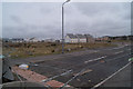
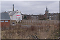
Renfrew housing development
Development here appears to have stalled as the houses are boarded-up.
Image: © Thomas Nugent
Taken: 29 Mar 2010
0.03 miles
2
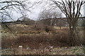
Marshland
A small piece of marsh land near the centre of Renfrew provides a source of food for a grey heron which is to the right of the centre. See a closer view of the heron here Image
Image: © Thomas Nugent
Taken: 29 Mar 2010
0.06 miles
3
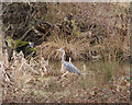
Grey Heron
A closer view of the heron seen here Image
Image: © Thomas Nugent
Taken: 29 Mar 2010
0.06 miles
4
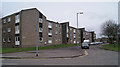
Renfrew housing development
On the south side of Kings Inch Road.
Image: © Thomas Nugent
Taken: 29 Mar 2010
0.06 miles
5
Anne Avenue
Near the centre of Renfrew.
Image: © Thomas Nugent
Taken: 29 Mar 2010
0.08 miles
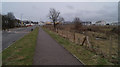
6
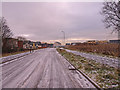
Icy Road, Renfrew
The new buildings of Braehead will soon join Renfrew.
Image: © wfmillar
Taken: 22 Dec 2009
0.10 miles
7

Electrical Sub-Station, Renfrew
Just outside the town but Braehead house building fast approaching.
Image: © wfmillar
Taken: 22 Dec 2009
0.11 miles
8
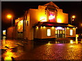
The Regal
Bingo hall on Ferry Road at Station Road, Renfrew.
Image: © Thomas Nugent
Taken: 5 Jan 2008
0.11 miles
9
Renfrew housing development
Looking towards Braehead. This apparently as yet unnamed road is an extension of Station Road and is to the south of Kings Inch Road.
Image: © Thomas Nugent
Taken: 29 Mar 2010
0.11 miles