IMAGES TAKEN NEAR TO
Port Charlotte, ISLE OF ISLAY, PA48 7UB
Introduction
This page details the photographs taken nearby to PA48 7UB by members of the Geograph project.
The Geograph project started in 2005 with the aim of publishing, organising and preserving representative images for every square kilometre of Great Britain, Ireland and the Isle of Man.

There are currently over 7.5m images from over14,400 individuals and you can help contribute to the project by visiting https://www.geograph.org.uk
Image Map
Images are licensed for reuse under creativecommons.org/licenses/by-sa/2.0
Notes
- Clicking on the map will re-center to the selected point.
- The higher the marker number, the further away the image location is from the centre of the postcode.
Image Listing (19 Images Found)
Images are licensed for reuse under creativecommons.org/licenses/by-sa/2.0
Image
Details
Distance
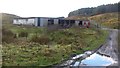
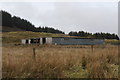
4
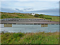
Outbuildings at Gearach
With Gearach itself in the background.
Image: © John Allan
Taken: 28 Jul 2011
0.10 miles
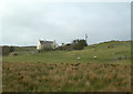
5
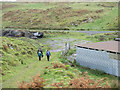
Minor road near to Gearach
Three hill walkers are passing through a deserted farming or industrial site to reach a minor road west of Port Charlotte.
Image: © Trevor Littlewood
Taken: 29 Oct 2016
0.10 miles
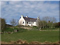
8
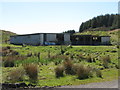
Farm stock sheds at Gearach
For an earlier view see Becky Williamson's picture from 2012 Image
Image: © M J Richardson
Taken: 13 May 2018
0.11 miles
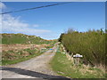
9
Barns at Gearach
Farm barns at Gearach
Image: © Andrew Abbott
Taken: 20 Apr 2019
0.11 miles