IMAGES TAKEN NEAR TO
The Oa, ISLE OF ISLAY, PA42 7AZ
Introduction
This page details the photographs taken nearby to PA42 7AZ by members of the Geograph project.
The Geograph project started in 2005 with the aim of publishing, organising and preserving representative images for every square kilometre of Great Britain, Ireland and the Isle of Man.

There are currently over 7.5m images from over14,400 individuals and you can help contribute to the project by visiting https://www.geograph.org.uk
Image Map
Images are licensed for reuse under creativecommons.org/licenses/by-sa/2.0
Notes
- Clicking on the map will re-center to the selected point.
- The higher the marker number, the further away the image location is from the centre of the postcode.
Image Listing (3 Images Found)
Images are licensed for reuse under creativecommons.org/licenses/by-sa/2.0
Image
Details
Distance
1
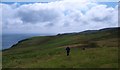
Following the clifftop path
OS maps show a clear path heading SSW along the 70m contour line towards Lurabus. This may exist on the map, but is hard to find on the ground, whilst the crossing of a barbed wire fence doesn't make progress any easier. The short section from Lurabus to the track corner is a swamp and is best avoided. A lot easier to use the broad track some 30m higher up the hillside.
Image: © Gordon Hatton
Taken: 18 Jul 2011
0.10 miles
2
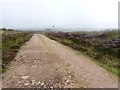
Track to Port an Eas, Islay
Several houses have recently been built along this track which are not shown on the map. The one in the distance is just in the next gridsquare, NR3444. The track passes several ruins and leads to the cliffs above the beautiful Port an Eas.
Image: © Becky Williamson
Taken: 27 Aug 2013
0.15 miles
3
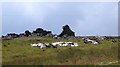
Goats and ruins
Some of the many wild goats that inhabit the Oa peninsula, seen here by a ruined settlement at Torr an Dobhrain.
Image: © Gordon Hatton
Taken: 18 Jul 2011
0.19 miles