IMAGES TAKEN NEAR TO
Haining Road, RENFREW, PA4 0TJ
Introduction
This page details the photographs taken nearby to Haining Road, PA4 0TJ by members of the Geograph project.
The Geograph project started in 2005 with the aim of publishing, organising and preserving representative images for every square kilometre of Great Britain, Ireland and the Isle of Man.

There are currently over 7.5m images from over14,400 individuals and you can help contribute to the project by visiting https://www.geograph.org.uk
Image Map
Images are licensed for reuse under creativecommons.org/licenses/by-sa/2.0
Notes
- Clicking on the map will re-center to the selected point.
- The higher the marker number, the further away the image location is from the centre of the postcode.
Image Listing (31 Images Found)
Images are licensed for reuse under creativecommons.org/licenses/by-sa/2.0
Image
Details
Distance
2
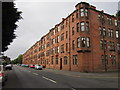
Oxford Road
Looking from the Paisley Road end.
Image: © Richard Sutcliffe
Taken: 5 May 2017
0.11 miles
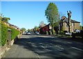
4
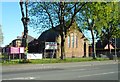
Re-roofing St Margaret's Church
St Margaret's Scottish Episcopal Church at the corner of Paisley Road and Oxford Road, Renfrew was built in 1914. It is currently being re-roofed for the first time since it was built.
Image: © Richard Sutcliffe
Taken: 5 May 2017
0.14 miles
5
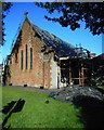
Re-roofing St Margaret's Church
St Margaret's Scottish Episcopal Church at the corner of Paisley Road and Oxford Road, Renfrew was built in 1914. It is currently being re-roofed for the first time since it was built. The old slates have been removed, and the remains are lying in a pile on the grass.
Image: © Richard Sutcliffe
Taken: 5 May 2017
0.14 miles
7
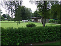
Robertson Park Bowling Club
Viewed from the skateboard & BMX park.
Image: © Thomas Nugent
Taken: 4 Sep 2010
0.15 miles
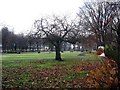
8
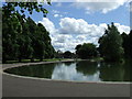
Pond in Robertson Park
At the Craigielea Road end of the park.
Image: © Thomas Nugent
Taken: 23 Jun 2008
0.16 miles
9
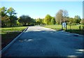
Redevelopments in Robertson Park
The entrance at the southern end of the park is closed from 20th March until 7th August 2017 while 'park redevelopment works' take place.
Image: © Richard Sutcliffe
Taken: 5 May 2017
0.16 miles
10
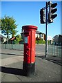
Edward VII pillar box
Edward VII pillar box outside the entrance to Robertson Park at the junction of Paisley Road and Craigielea Road. The postbox number is PA4 69.
Image: © Richard Sutcliffe
Taken: 5 May 2017
0.16 miles