IMAGES TAKEN NEAR TO
Friendship Way, RENFREW, PA4 0NX
Introduction
This page details the photographs taken nearby to Friendship Way, PA4 0NX by members of the Geograph project.
The Geograph project started in 2005 with the aim of publishing, organising and preserving representative images for every square kilometre of Great Britain, Ireland and the Isle of Man.

There are currently over 7.5m images from over14,400 individuals and you can help contribute to the project by visiting https://www.geograph.org.uk
Image Map
Images are licensed for reuse under creativecommons.org/licenses/by-sa/2.0
Notes
- Clicking on the map will re-center to the selected point.
- The higher the marker number, the further away the image location is from the centre of the postcode.
Image Listing (41 Images Found)
Images are licensed for reuse under creativecommons.org/licenses/by-sa/2.0
Image
Details
Distance
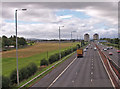
1
M8 Motorway
About 1km west of Junction 26.
Image: © Richard Sutcliffe
Taken: 23 Feb 2024
0.10 miles
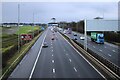
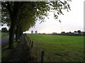
3
Between Arkleston Road and the motorway
A strip of poor quality grassland lies between Arkleston Road (on the left) and the M8 motorway (on the right). Seen from the footbridge over the motorway.
Image: © Richard Sutcliffe
Taken: 23 Feb 2024
0.12 miles
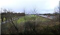
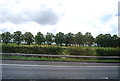
4
Avenue of trees leading to Arkleston Cemetery
Arkleston Road with M8 Motorway roaring past on the right.
Image: © Chris Upson
Taken: 30 Sep 2005
0.12 miles
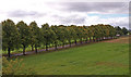
5
Trees lining Arkleston Rd
Seen from the M8.
Image: © N Chadwick
Taken: 16 Jul 2011
0.13 miles
6
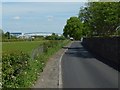
Arkleston Road
The boundary wall of Arkleston Cemetery — http://www.geograph.org.uk/snippet/10005 — is on the right.
Image: © Lairich Rig
Taken: 19 May 2018
0.14 miles
7
Tree-lined Arkleston Road
Near the M8 footbridge.
Image: © wfmillar
Taken: 10 Sep 2010
0.14 miles
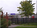
8

Arkleston Road
The picture was taken from beside the Image In the left background is a footbridge crossing above the M8, as depicted on the OS map, and as shown in Image and Image; that footbridge would later be replaced: Image
On the right, in the distance, is the top of a large building: Merlin House (Image), on Mossland Road in Hillington Park.
See Image for a side view of the same section of road.
Image: © Lairich Rig
Taken: 4 Nov 2013
0.14 miles
9
Main entrance of Arkleston Cemetery
See Image for a view from the other side.
Image: © Lairich Rig
Taken: 11 Jan 2014
0.14 miles