IMAGES TAKEN NEAR TO
Cockels Loan, RENFREW, PA4 0ER
Introduction
This page details the photographs taken nearby to Cockels Loan, PA4 0ER by members of the Geograph project.
The Geograph project started in 2005 with the aim of publishing, organising and preserving representative images for every square kilometre of Great Britain, Ireland and the Isle of Man.

There are currently over 7.5m images from over14,400 individuals and you can help contribute to the project by visiting https://www.geograph.org.uk
Image Map
Images are licensed for reuse under creativecommons.org/licenses/by-sa/2.0
Notes
- Clicking on the map will re-center to the selected point.
- The higher the marker number, the further away the image location is from the centre of the postcode.
Image Listing (40 Images Found)
Images are licensed for reuse under creativecommons.org/licenses/by-sa/2.0
Image
Details
Distance
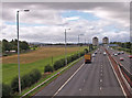
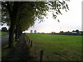
3
Hillington Footbridge: northern steps
The road between the grass and the trees is Cockels Loan. Behind the trees is a playing field of Arkleston Primary School. The nearer houses visible through a gap in the trees are on Allen Way. The large silvery building behind them is a superstore.
Image: © Lairich Rig
Taken: 19 May 2018
0.08 miles
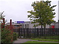
5
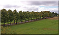
Tree-lined Arkleston Road
Near the M8 footbridge.
Image: © wfmillar
Taken: 10 Sep 2010
0.09 miles
6
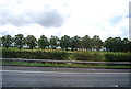
Trees lining Arkleston Rd
Seen from the M8.
Image: © N Chadwick
Taken: 16 Jul 2011
0.09 miles
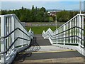
7
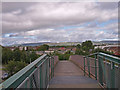
Footbridge, Arkleston
Crossing the M8. View over Renfrew to the Kilpatric Hills.
Image: © wfmillar
Taken: 10 Sep 2010
0.09 miles
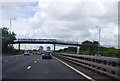
8

M8 heading for Junction 27
The footbridge at Arkleston crossing the motorway. See Image
Image: © wfmillar
Taken: 17 Jan 2011
0.09 miles
9
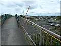
Hillington Footbridge
The central span of the replacement footbridge (see the end-note) can be seen in the right background. The temporary repairs made in 2010 involved the installation of a bridging section over the damaged span; that bridging section can be seen on the left. See https://www.transport.gov.scot/projects/m8-hillington-footbridge-replacement/m8-hillington-footbridge-replacement/ (at Transport Scotland) for further information.
For other views of the existing bridge, as it looked in 2010, see Image / Image
Image: © Lairich Rig
Taken: 31 Aug 2015
0.10 miles
10
Avenue of trees leading to Arkleston Cemetery
Arkleston Road with M8 Motorway roaring past on the right.
Image: © Chris Upson
Taken: 30 Sep 2005
0.10 miles