IMAGES TAKEN NEAR TO
Cumbrae Road, RENFREW, PA4 0DS
Introduction
This page details the photographs taken nearby to Cumbrae Road, PA4 0DS by members of the Geograph project.
The Geograph project started in 2005 with the aim of publishing, organising and preserving representative images for every square kilometre of Great Britain, Ireland and the Isle of Man.

There are currently over 7.5m images from over14,400 individuals and you can help contribute to the project by visiting https://www.geograph.org.uk
Image Map
Images are licensed for reuse under creativecommons.org/licenses/by-sa/2.0
Notes
- Clicking on the map will re-center to the selected point.
- The higher the marker number, the further away the image location is from the centre of the postcode.
Image Listing (28 Images Found)
Images are licensed for reuse under creativecommons.org/licenses/by-sa/2.0
Image
Details
Distance
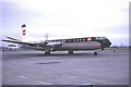
3
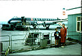
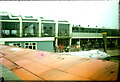
Plane at Glasgow (Renfrew) Airport
A BEA Vickers Viscount plane waiting to take off from the airport. It was en route for Birmingham Elmdon and Paris. This is the reverse shot to Image Only a temporary barrier separates the public viewing area from the runway apron.
Image: © Nigel Mykura
Taken: 11 Jul 1961
0.15 miles
5
Glasgow (Renfrew) Airport
This is the rear of the terminal building from a BEA Vickers Viscount plane on a flight to Birmingham Elmdon and Paris. It shows the small public viewing area just in front of the terminal. The arch which framed the front entrance to the building can just be seen in the top left of the image. It is the reverse shot of Image
Image: © Nigel Mykura
Taken: 11 Jul 1961
0.17 miles
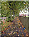
6
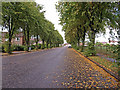
Broadloan, Renfrew
Wide tree lined street adjacent to King George V Memorial Playing Fields.
Image: © wfmillar
Taken: 10 Sep 2010
0.18 miles
7
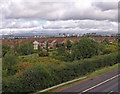
Dean Park, Renfrew
View from the M8 footbridge looking to the Campsie Fells
Image: © wfmillar
Taken: 10 Sep 2010
0.19 miles
8
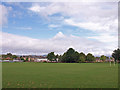
King George V Memorial Playing Fields, Renfrew
Near Renfrew High School.
Image: © wfmillar
Taken: 10 Sep 2010
0.20 miles
9
BEA at Renfrew Airport
It took a lot of research to pin point this location but thankfully with the use of NLS maps I was able to pinpoint fairly accurately the location. The site today is in a middle of a housing estate. Renfrew Airport closed in 1966 and the site at Abbotsinch became the airport for Glasgow. The dockside cranes along the River clyde can be just made out in the background.
Image: © Richard Park
Taken: Unknown
0.21 miles
10
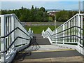
Hillington Footbridge: northern steps
The road between the grass and the trees is Cockels Loan. Behind the trees is a playing field of Arkleston Primary School. The nearer houses visible through a gap in the trees are on Allen Way. The large silvery building behind them is a superstore.
Image: © Lairich Rig
Taken: 19 May 2018
0.21 miles