IMAGES TAKEN NEAR TO
Pearson Drive, RENFREW, PA4 0BG
Introduction
This page details the photographs taken nearby to Pearson Drive, PA4 0BG by members of the Geograph project.
The Geograph project started in 2005 with the aim of publishing, organising and preserving representative images for every square kilometre of Great Britain, Ireland and the Isle of Man.

There are currently over 7.5m images from over14,400 individuals and you can help contribute to the project by visiting https://www.geograph.org.uk
Image Map
Images are licensed for reuse under creativecommons.org/licenses/by-sa/2.0
Notes
- Clicking on the map will re-center to the selected point.
- The higher the marker number, the further away the image location is from the centre of the postcode.
Image Listing (48 Images Found)
Images are licensed for reuse under creativecommons.org/licenses/by-sa/2.0
Image
Details
Distance
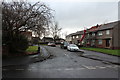
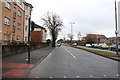
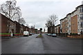
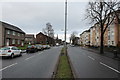
5
High Street, Renfrew
Leaving Renfrew on the east side of the town.
Image: © Richard Webb
Taken: 4 Jan 2016
0.10 miles
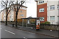
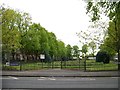
7
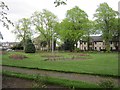
Park, Loanhead
A small park off Sandy Road.
Image: © Richard Webb
Taken: 21 May 2013
0.11 miles