IMAGES TAKEN NEAR TO
Kirk Side, APPIN, PA38 4AA
Introduction
This page details the photographs taken nearby to Kirk Side, PA38 4AA by members of the Geograph project.
The Geograph project started in 2005 with the aim of publishing, organising and preserving representative images for every square kilometre of Great Britain, Ireland and the Isle of Man.

There are currently over 7.5m images from over14,400 individuals and you can help contribute to the project by visiting https://www.geograph.org.uk
Image Map
Images are licensed for reuse under creativecommons.org/licenses/by-sa/2.0
Notes
- Clicking on the map will re-center to the selected point.
- The higher the marker number, the further away the image location is from the centre of the postcode.
Image Listing (17 Images Found)
Images are licensed for reuse under creativecommons.org/licenses/by-sa/2.0
Image
Details
Distance
1
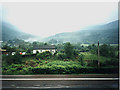
A828 at Duror
Duror, on a misty evening, taken from the Duror Hotel.
Image: © Peter Craine
Taken: 22 Jun 2003
0.04 miles
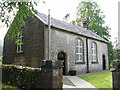
2
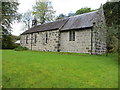
The Church of St Adamnan at Duror
Viewed from the east.
Image: © Peter Wood
Taken: 25 Sep 2019
0.05 miles
7
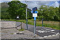
New cycle track and walkway
The new track generally follows the line of the old Ballachulish railway, but here it diverts slightly to avoid the caravan park.
Image: © Nigel Brown
Taken: 15 Jun 2013
0.14 miles
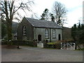
8
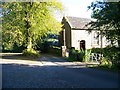
Duror Parish Church
In the West Highlands of Scotland
Image: © James Denham
Taken: 10 Jun 2009
0.14 miles
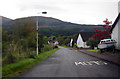
9
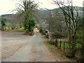
Track towards houses in Duror
The building on the right is Duror Parish Church.
Image: © Dave Fergusson
Taken: 8 Feb 2010
0.14 miles