IMAGES TAKEN NEAR TO
Barcaldine, OBAN, PA37 1SE
Introduction
This page details the photographs taken nearby to PA37 1SE by members of the Geograph project.
The Geograph project started in 2005 with the aim of publishing, organising and preserving representative images for every square kilometre of Great Britain, Ireland and the Isle of Man.

There are currently over 7.5m images from over14,400 individuals and you can help contribute to the project by visiting https://www.geograph.org.uk
Image Map
Images are licensed for reuse under creativecommons.org/licenses/by-sa/2.0
Notes
- Clicking on the map will re-center to the selected point.
- The higher the marker number, the further away the image location is from the centre of the postcode.
Image Listing (17 Images Found)
Images are licensed for reuse under creativecommons.org/licenses/by-sa/2.0
Image
Details
Distance
2
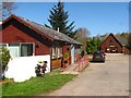
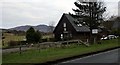
Twisted Wheel cafe - Dalrannoch
The Twisted Wheel cafe was once a nursery, but was closed by the Council as it did not have enough fire escapes. However, the cafe is still there - and does a mean "bacon butty".
Image: © The Carlisle Kid
Taken: 11 Jun 2011
0.01 miles
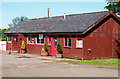
3
Twisted Wheel cafe and the pottery - Dalrannoch
Image: © Elliott Simpson
Taken: 30 Sep 2013
0.02 miles
4
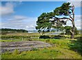
Scots Pine at Dalrannoch
Old scots pine at Dalrannoch.
Image: © Colin Kinnear
Taken: 25 Aug 2023
0.02 miles
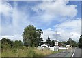
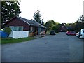
9
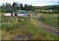
Dalrannoch Farm
Bed and breakfast is the main business at this former farm by Loch Creran.
Image: © Walter Baxter
Taken: 17 Jun 2012
0.10 miles
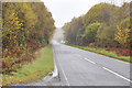
10
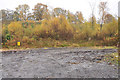
Parking area for forestry equipment beside the A828
Image: © Steven Brown
Taken: 4 Nov 2010
0.11 miles