IMAGES TAKEN NEAR TO
North Ledaig, OBAN, PA37 1RU
Introduction
This page details the photographs taken nearby to PA37 1RU by members of the Geograph project.
The Geograph project started in 2005 with the aim of publishing, organising and preserving representative images for every square kilometre of Great Britain, Ireland and the Isle of Man.

There are currently over 7.5m images from over14,400 individuals and you can help contribute to the project by visiting https://www.geograph.org.uk
Image Map
Images are licensed for reuse under creativecommons.org/licenses/by-sa/2.0
Notes
- Clicking on the map will re-center to the selected point.
- The higher the marker number, the further away the image location is from the centre of the postcode.
Image Listing (28 Images Found)
Images are licensed for reuse under creativecommons.org/licenses/by-sa/2.0
Image
Details
Distance
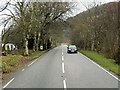
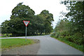
3
North Ledaig bus stop
The flank of Beinn Lora can be seen in the distance.
Image: © Martin Ragg
Taken: 24 Oct 2012
0.03 miles
4
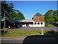
Caravan Club Site Office & Shop, North Ledaig
Image: © Bill Henderson
Taken: 6 Jun 2013
0.03 miles
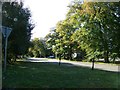
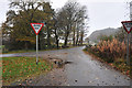
5
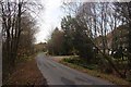
Minor road nearing the A828 at North Ledaig
Image: © Alan Reid
Taken: 18 Nov 2014
0.05 miles
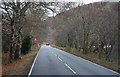
8
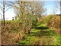
Ballachulish Branch trackbed
The trackbed here at Ledaig has not been resurfaced or upgraded, but is not obstructed and is easy to use.
Image: © Richard Webb
Taken: 18 Apr 2014
0.06 miles
9
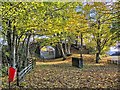
Old Railway Bridge at North Ledaig
The line became defunct in 1966 when the Ballachulish Branch of the Callander and Oban Railway closed
Image: © Martin Ragg
Taken: 22 Oct 2012
0.06 miles