IMAGES TAKEN NEAR TO
Etive Road, OBAN, PA37 1QF
Introduction
This page details the photographs taken nearby to Etive Road, PA37 1QF by members of the Geograph project.
The Geograph project started in 2005 with the aim of publishing, organising and preserving representative images for every square kilometre of Great Britain, Ireland and the Isle of Man.

There are currently over 7.5m images from over14,400 individuals and you can help contribute to the project by visiting https://www.geograph.org.uk
Image Map
Images are licensed for reuse under creativecommons.org/licenses/by-sa/2.0
Notes
- Clicking on the map will re-center to the selected point.
- The higher the marker number, the further away the image location is from the centre of the postcode.
Image Listing (19 Images Found)
Images are licensed for reuse under creativecommons.org/licenses/by-sa/2.0
Image
Details
Distance
6
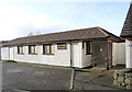
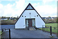
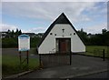
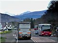
Kingdom Hall of Jehovah's Witnesses - Dunbeg
This was once the Community Hall
Image: © Peter Amsden
Taken: 17 Feb 2006
0.11 miles
10
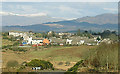
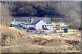
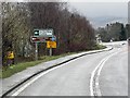
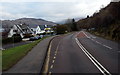
Dunbeg from the A85
View looking North West. If development plans go ahead then much of the land seen in the foreground will be built on, expanding the village by approx.150 houses.
Image: © Peter Amsden
Taken: 21 Feb 2006
0.16 miles