IMAGES TAKEN NEAR TO
Fearnoch, TAYNUILT, PA35 1JB
Introduction
This page details the photographs taken nearby to Fearnoch, PA35 1JB by members of the Geograph project.
The Geograph project started in 2005 with the aim of publishing, organising and preserving representative images for every square kilometre of Great Britain, Ireland and the Isle of Man.

There are currently over 7.5m images from over14,400 individuals and you can help contribute to the project by visiting https://www.geograph.org.uk
Image Map
Images are licensed for reuse under creativecommons.org/licenses/by-sa/2.0
Notes
- Clicking on the map will re-center to the selected point.
- The higher the marker number, the further away the image location is from the centre of the postcode.
Image Listing (7 Images Found)
Images are licensed for reuse under creativecommons.org/licenses/by-sa/2.0
Image
Details
Distance
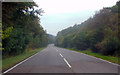
2
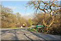
Road to Fearnoch Forest
This great forest has some wonderful walks, cycle tracks and picnic areas
Image: © James Denham
Taken: 30 Jun 2008
0.15 miles
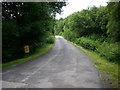
4
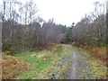
Forest road, Fearnoch
Appears to be mainly used by bikes and pedestrians at the moment.
Image: © Richard Webb
Taken: 6 Apr 2019
0.19 miles
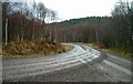
6
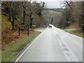
A85 and the junction for the road to Fearnoch forest
Image: © Steven Brown
Taken: 3 May 2010
0.22 miles