IMAGES TAKEN NEAR TO
Renfrew Road, PAISLEY, PA3 4EF
Introduction
This page details the photographs taken nearby to Renfrew Road, PA3 4EF by members of the Geograph project.
The Geograph project started in 2005 with the aim of publishing, organising and preserving representative images for every square kilometre of Great Britain, Ireland and the Isle of Man.

There are currently over 7.5m images from over14,400 individuals and you can help contribute to the project by visiting https://www.geograph.org.uk
Image Map
Images are licensed for reuse under creativecommons.org/licenses/by-sa/2.0
Notes
- Clicking on the map will re-center to the selected point.
- The higher the marker number, the further away the image location is from the centre of the postcode.
Image Listing (38 Images Found)
Images are licensed for reuse under creativecommons.org/licenses/by-sa/2.0
Image
Details
Distance
1
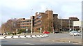
Trident House
Office block crammed between the M8 motorway and Renfrew Road.
Image: © Thomas Nugent
Taken: 29 Mar 2007
0.01 miles
2

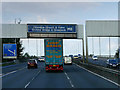
M8 at Junction 27
Looking west towards the White Cart viaduct which can just be made out beyond the overhead gantry,
Image: © G Laird
Taken: 1 Nov 2013
0.04 miles
3

M8 near Paisley
A busy stretch, leading to Glasgow Airport.
Image: © Stephen Sweeney
Taken: 7 Aug 2007
0.05 miles
4
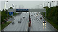
The M8 motorway at Arkleston
Looking west from the Renfrew Road flyover towards the White Cart Viaduct.
Image: © Thomas Nugent
Taken: 15 May 2017
0.05 miles
5
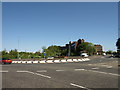
A741 Roundabout
Just at the entrance to Abbotsinch Retail Park. The dark building is an office block.
Image: © wfmillar
Taken: 13 May 2009
0.07 miles
6

Renfrew Road Bridge over the M8 at Gallowhill
Image: © David Dixon
Taken: 26 Sep 2019
0.09 miles
7
M8 White Cart viaduct
The viaduct opened in 1968 and has been undergoing essential repairs and upgrade since July 2010. Work is currently taking place under the bridge deck and this requires speed restrictions for all lanes in all direction.
Image: © Thomas Nugent
Taken: 18 Feb 2012
0.10 miles
8

Airport buildings in Sandyford Road
From M8 eastbound just prior to junction 27
Image: © John Firth
Taken: 13 May 2011
0.10 miles
9
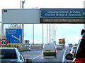
Sign Gantry over the M8 at Arkleston Interchange
A typical “Glasgow-type” sign gantry approaching Junction 28 of the M8 near Glasgow Airport.
Gantries of this type were first erected as part of the construction of the Kingston Bridge and its approach roads in 1970 and they are now a familiar sight on the motorway network around Glasgow. They have the following distinctive elements:
• near and offside support legs (basically 2 rectangular hollow sections with base plates to allow connections to the foundations),
• a Main Frame (made up of rectangular hollow sections) - Over clad on the front and rear,
• a Sub Frame (made up of smaller hollow sections and welded to main frame),
• a Sign Face - acrylic sheets hung from the front of the sub frame over its full height,
• internal Electrics - sign lighting provided through the use of several dozen fluorescent battens.
More information on “Glasgow Style Gantries” at https://web.archive.org/web/20141106003519/http://www.glasgows-motorways.co.uk/glasgow-gantries/4578281645
(Glasgow’s Motorways, archived November 2014)
Image: © David Dixon
Taken: 26 Sep 2019
0.10 miles
10
Gap site on Renfrew Road
Taken from the cycle path at The Junction retail park.
Image: © Thomas Nugent
Taken: 21 Dec 2008
0.11 miles