IMAGES TAKEN NEAR TO
Riverside Road, OBAN, PA34 4ZD
Introduction
This page details the photographs taken nearby to Riverside Road, PA34 4ZD by members of the Geograph project.
The Geograph project started in 2005 with the aim of publishing, organising and preserving representative images for every square kilometre of Great Britain, Ireland and the Isle of Man.

There are currently over 7.5m images from over14,400 individuals and you can help contribute to the project by visiting https://www.geograph.org.uk
Image Map
Images are licensed for reuse under creativecommons.org/licenses/by-sa/2.0
Notes
- Clicking on the map will re-center to the selected point.
- The higher the marker number, the further away the image location is from the centre of the postcode.
Image Listing (14 Images Found)
Images are licensed for reuse under creativecommons.org/licenses/by-sa/2.0
Image
Details
Distance
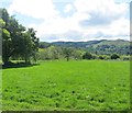
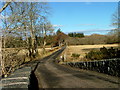
1
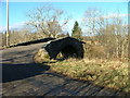
Bridge over Feochan Mhor
On the Musdale to Kilmore road.
Image: © Dave Fergusson
Taken: 9 Feb 2010
0.03 miles
5
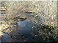
Feochan Mhor
Looking downstream. The river is also known as the River Nell.
Image: © Dave Fergusson
Taken: 9 Feb 2010
0.08 miles
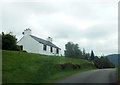
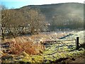
6
Musdale to Kilmore road
Looking north at Barran.
Image: © Dave Fergusson
Taken: 9 Feb 2010
0.09 miles
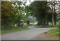
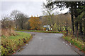
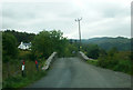
7
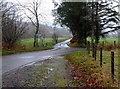
Road junction at Barran
The road turning right goes back to the main road at Kilmore.
Image: © Gordon Brown
Taken: 1 Dec 2015
0.09 miles