IMAGES TAKEN NEAR TO
Blackmill Bay, OBAN, PA34 4TZ
Introduction
This page details the photographs taken nearby to Blackmill Bay, PA34 4TZ by members of the Geograph project.
The Geograph project started in 2005 with the aim of publishing, organising and preserving representative images for every square kilometre of Great Britain, Ireland and the Isle of Man.

There are currently over 7.5m images from over14,400 individuals and you can help contribute to the project by visiting https://www.geograph.org.uk
Image Map
Images are licensed for reuse under creativecommons.org/licenses/by-sa/2.0
Notes
- Clicking on the map will re-center to the selected point.
- The higher the marker number, the further away the image location is from the centre of the postcode.
Image Listing (33 Images Found)
Images are licensed for reuse under creativecommons.org/licenses/by-sa/2.0
Image
Details
Distance
1
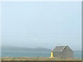
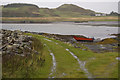
House at Blackmill Bay
House on the shore of the Sound of Luing. Beyond the sound, the bleak mountainous Isle of Scarba.
Image: © Oliver Dixon
Taken: 8 Sep 2014
0.03 miles
3
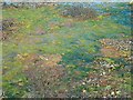
The colours of algae
Blackmill Bay at low tide.
Image: © Patrick Mackie
Taken: 13 May 2006
0.04 miles
4
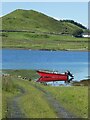
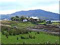
Luing - Boat in Black Mill Bay
This striking little red boat moored in Black Mill Bay on the west coast of the Isle of Luing caught my attention with its almost perfect reflection in the water.
The hill in the background is Cnoc Mòr which rises to 184' (56m).
Image: © Rob Farrow
Taken: 30 Jun 2022
0.05 miles
5
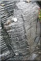
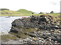
Metamorphic rock
The islands of Seil, Luing and Easdale, and some of the smaller ones nearby, are known as the Slate Islands because they were formerly extensively quarried for slate. Slate is mudstone or siltstone which has been altered by heat and pressure. As the temperature and pressure increase, it first forms slate, then phyllite, then schist, and then gneiss, before melting altogether. The geological map describes the lithology of the islands as graphitic schist and slate, and these rocks are probably phyllite, because they have a definite sheen but no crystals obvious to the naked eye. The beach pebbles show almost translucent stripes.
Image: © Anne Burgess
Taken: 27 Apr 2010
0.05 miles
6
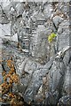
Metamorphic rock
This is a wider view of the rocks shown in Image The islands of Seil, Luing and Easdale, and some of the smaller ones nearby, are known as the Slate Islands because they were formerly extensively quarried for slate. Slate is mudstone or siltstone which has been altered by heat and pressure. As the temperature and pressure increase, it first forms slate, then phyllite, then schist, and then gneiss, before melting altogether. The geological map describes the lithology of the islands as graphitic schist and slate, and these rocks are probably phyllite, because they have a definite sheen but no crystals obvious to the naked eye. The beach pebbles show almost translucent stripes.
Image: © Anne Burgess
Taken: 27 Apr 2010
0.06 miles
8
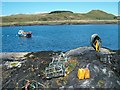
Back from the creels
This fisherman had returned from checking his creels around the islands of Scarba and Jura, sailing back up the Sound of Luing on the flood tide.
Image: © Patrick Mackie
Taken: 13 May 2006
0.07 miles
9
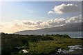
Rubha Cuil
The headland at the end of a track and the view over the Sound of Luing.
Image: © Andrew Wood
Taken: 28 Oct 2008
0.08 miles