IMAGES TAKEN NEAR TO
Balvicar, OBAN, PA34 4TE
Introduction
This page details the photographs taken nearby to PA34 4TE by members of the Geograph project.
The Geograph project started in 2005 with the aim of publishing, organising and preserving representative images for every square kilometre of Great Britain, Ireland and the Isle of Man.

There are currently over 7.5m images from over14,400 individuals and you can help contribute to the project by visiting https://www.geograph.org.uk
Image Map
Images are licensed for reuse under creativecommons.org/licenses/by-sa/2.0
Notes
- Clicking on the map will re-center to the selected point.
- The higher the marker number, the further away the image location is from the centre of the postcode.
Image Listing (5 Images Found)
Images are licensed for reuse under creativecommons.org/licenses/by-sa/2.0
Image
Details
Distance
1
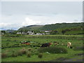
The Isle of Seil Golf Course
Cattle pasture, with the smoother golf course beyond.
Image: © M J Richardson
Taken: 27 May 2019
0.16 miles
2
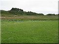
Trees on a ridge at Balvicar
With drained pasture. The ridge is formed of very old Neoproterozoic intrusive, metamorphic, metabasaltic and metadoleritic rocks 1000-550 million years old.
Image: © M J Richardson
Taken: 27 May 2019
0.16 miles
4
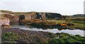
Track to Rubha nan R?n
At the end of the road from Balvicar, with the Sound of Seil and Armaddy beyond.
Image: © M J Richardson
Taken: 27 May 2019
0.18 miles
5
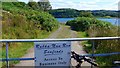
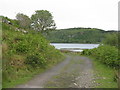
Entry to Rubha-Nan-Ron Seafoods, Seil
The waters of Seil Sound beyond.
Image: © Gordon Brown
Taken: 7 Jul 2019
0.18 miles