IMAGES TAKEN NEAR TO
Glenshellach Road, OBAN, PA34 4PP
Introduction
This page details the photographs taken nearby to Glenshellach Road, PA34 4PP by members of the Geograph project.
The Geograph project started in 2005 with the aim of publishing, organising and preserving representative images for every square kilometre of Great Britain, Ireland and the Isle of Man.

There are currently over 7.5m images from over14,400 individuals and you can help contribute to the project by visiting https://www.geograph.org.uk
Image Map
Images are licensed for reuse under creativecommons.org/licenses/by-sa/2.0
Notes
- Clicking on the map will re-center to the selected point.
- The higher the marker number, the further away the image location is from the centre of the postcode.
Image Listing (9 Images Found)
Images are licensed for reuse under creativecommons.org/licenses/by-sa/2.0
Image
Details
Distance
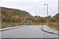
3
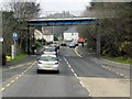
Railway bridge with road leading to Lochavullin Industrial Estate
Image: © Steven Brown
Taken: 17 Sep 2012
0.13 miles
5
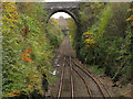
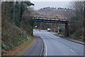
Railway heading south from Oban
The scene here appears to be entirely rural but it's a view from near the centre of a town - albeit a small one.
Image: © Trevor Littlewood
Taken: 29 Oct 2008
0.17 miles
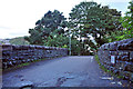
6
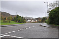
Road junction near the Lorn and Island Hospital
Image: © Steven Brown
Taken: 4 Nov 2010
0.22 miles