IMAGES TAKEN NEAR TO
Richmond Drive, PAISLEY, PA3 3TG
Introduction
This page details the photographs taken nearby to Richmond Drive, PA3 3TG by members of the Geograph project.
The Geograph project started in 2005 with the aim of publishing, organising and preserving representative images for every square kilometre of Great Britain, Ireland and the Isle of Man.

There are currently over 7.5m images from over14,400 individuals and you can help contribute to the project by visiting https://www.geograph.org.uk
Image Map
Images are licensed for reuse under creativecommons.org/licenses/by-sa/2.0
Notes
- Clicking on the map will re-center to the selected point.
- The higher the marker number, the further away the image location is from the centre of the postcode.
Image Listing (9 Images Found)
Images are licensed for reuse under creativecommons.org/licenses/by-sa/2.0
Image
Details
Distance
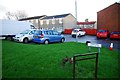
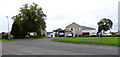
2
Houses and caravans at East Fulton Small Holdings
In Linwood.
Image: © Stephen Sweeney
Taken: 24 Feb 2011
0.11 miles
3
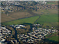
East Fulton from the air
On the outskirts of Linwood. See also Image
Image: © Thomas Nugent
Taken: 9 Dec 2019
0.19 miles
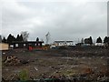
4
East Fulton
Various businesses are located on this edge of town farm off Dalruith Road.
Image: © Thomas Nugent
Taken: 7 Sep 2018
0.19 miles
5
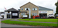
Businesses at East Fulton
Various businesses are located on this edge of town farm off Dalruith Road.
Image: © Thomas Nugent
Taken: 7 Sep 2018
0.19 miles
6
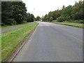
Clippens Road
Looking towards East Fulton.
Image: © Thomas Nugent
Taken: 7 Sep 2018
0.19 miles
7
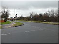
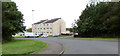
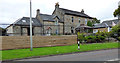
School zone, Darluith Road
At the bottom of Craig Road.
Image: © Stephen Sweeney
Taken: 24 Feb 2011
0.20 miles
8
East Fulton
On the edge of Linwood on Dalruith Road.
Image: © Thomas Nugent
Taken: 7 Sep 2018
0.21 miles