IMAGES TAKEN NEAR TO
Lochawe, DALMALLY, PA33 1AW
Introduction
This page details the photographs taken nearby to PA33 1AW by members of the Geograph project.
The Geograph project started in 2005 with the aim of publishing, organising and preserving representative images for every square kilometre of Great Britain, Ireland and the Isle of Man.

There are currently over 7.5m images from over14,400 individuals and you can help contribute to the project by visiting https://www.geograph.org.uk
Image Map
Images are licensed for reuse under creativecommons.org/licenses/by-sa/2.0
Notes
- Clicking on the map will re-center to the selected point.
- The higher the marker number, the further away the image location is from the centre of the postcode.
Image Listing (7 Images Found)
Images are licensed for reuse under creativecommons.org/licenses/by-sa/2.0
Image
Details
Distance
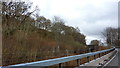
1
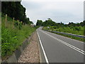
Twisting road just before you enter Lochawe village.
Image: © Johnny Durnan
Taken: 2 Jul 2006
0.13 miles
2
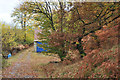
Shed beside the track to Tigh Cherracher
Image: © Steven Brown
Taken: 4 Nov 2012
0.16 miles
3
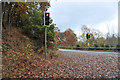
Traffic lights at the railway bridge at Loch Awe
Image: © Steven Brown
Taken: 4 Nov 2012
0.17 miles
4
Traffic lights controlling railway bridge on the A85
Image: © Steve Fareham
Taken: 21 May 2013
0.18 miles
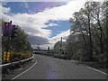
5
A85 Over West Highland Line, Loch Awe
The A85 crosses the West Highland Line (Oban branch). The bridge is traffic light controlled to allow only one direction of traffic.
Image: © Richard Cooke
Taken: 8 Apr 2016
0.18 miles
6
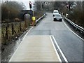
A85 Crossing The Railway
The road turns sharply to pass over the mainline railway at a narrow bridge with single line traffic controlled by traffic lights.
Image: © David Dixon
Taken: 25 Mar 2014
0.18 miles
7
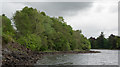
Trees on north shore of Loch Awe
The near trees are on the south side of the A85 south-west of the linear village of Lochawe. The more distant, darker trees are on the island, Innis Chonain.
Image: © Trevor Littlewood
Taken: 20 May 2017
0.25 miles