IMAGES TAKEN NEAR TO
Moncrieff Street, PAISLEY, PA3 2BE
Introduction
This page details the photographs taken nearby to Moncrieff Street, PA3 2BE by members of the Geograph project.
The Geograph project started in 2005 with the aim of publishing, organising and preserving representative images for every square kilometre of Great Britain, Ireland and the Isle of Man.

There are currently over 7.5m images from over14,400 individuals and you can help contribute to the project by visiting https://www.geograph.org.uk
Image Map
Images are licensed for reuse under creativecommons.org/licenses/by-sa/2.0
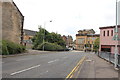
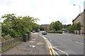
Notes
- Clicking on the map will re-center to the selected point.
- The higher the marker number, the further away the image location is from the centre of the postcode.
Image Listing (1024 Images Found)
Images are licensed for reuse under creativecommons.org/licenses/by-sa/2.0
Image
Details
Distance

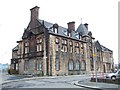
3

Former Welfare Offices
The Paisley Coat of Arms above the door of the Category B Listed http://www.scottisharchitects.org.uk/architect_full.php?id=100003 former Welfare Offices on Maxwell Street at Back Sneddon Street.
See the building here Image
Image: © Thomas Nugent
Taken: 17 Sep 2017
0.03 miles
4
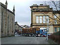
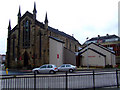
Log lorry in central Paisley
Not a common sight in central Paisley - possibly diverted due to roadworks on the Cart viaduct on the nearby M8. The building on the left is the Scottish Episcopal Church of Holy Trinity and St Barnabas. The building behind is Paisley Sheriff Court Image
Image: © Thomas Nugent
Taken: 29 Mar 2007
0.03 miles
5

Former Welfare Offices
On Back Sneddon Street at Maxwell Street. Category B Listed http://portal.historicenvironment.scot/designation/LB38921 by local architect TG Abercrombie http://www.scottisharchitects.org.uk/architect_full.php?id=100003 .
Image: © Thomas Nugent
Taken: 17 Sep 2017
0.03 miles
7
Old Building on Back Sneddon Street
Number 20. Original use unknown, now home to Cactus Project (Turning Point). See building detail Image] & Image]
Image: © Thomas Nugent
Taken: 29 Mar 2007
0.04 miles
8
Love Street, Paisley
From the junction with Glen Street.
Image: © Billy McCrorie
Taken: 21 Aug 2013
0.04 miles
9
Church of Holy Trinity and St Barnabas
Sporting a new extension since this earlier photo from April 2007 Image
Image: © Thomas Nugent
Taken: 22 Nov 2010
0.04 miles
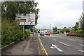
10
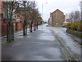
Love Street
The pedestrianised section in the foreground was created when the south end of the street was diverted when the ring road was created.
Image: © Thomas Nugent
Taken: 8 Jan 2017
0.04 miles