IMAGES TAKEN NEAR TO
Minard, INVERARAY, PA32 8YQ
Introduction
This page details the photographs taken nearby to PA32 8YQ by members of the Geograph project.
The Geograph project started in 2005 with the aim of publishing, organising and preserving representative images for every square kilometre of Great Britain, Ireland and the Isle of Man.

There are currently over 7.5m images from over14,400 individuals and you can help contribute to the project by visiting https://www.geograph.org.uk
Image Map
Images are licensed for reuse under creativecommons.org/licenses/by-sa/2.0
Notes
- Clicking on the map will re-center to the selected point.
- The higher the marker number, the further away the image location is from the centre of the postcode.
Image Listing (7 Images Found)
Images are licensed for reuse under creativecommons.org/licenses/by-sa/2.0
Image
Details
Distance
4
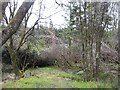
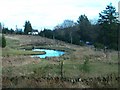
Windthrow, Coille Mh?r
A track goes nowhere as the forest has been blown down here. Clearing up this sort of mess is difficult and dangerous work - cut a trunk and things can spring up and get you, or the rootplates fall back. Either side of New Year 2012 a series of storms blew down 5,000,000 trees in Forestry Commission woodlands.
Image: © Richard Webb
Taken: 27 Apr 2012
0.08 miles