IMAGES TAKEN NEAR TO
INVERARAY, PA32 8XT
Introduction
This page details the photographs taken nearby to PA32 8XT by members of the Geograph project.
The Geograph project started in 2005 with the aim of publishing, organising and preserving representative images for every square kilometre of Great Britain, Ireland and the Isle of Man.

There are currently over 7.5m images from over14,400 individuals and you can help contribute to the project by visiting https://www.geograph.org.uk
Image Map
Images are licensed for reuse under creativecommons.org/licenses/by-sa/2.0
Notes
- Clicking on the map will re-center to the selected point.
- The higher the marker number, the further away the image location is from the centre of the postcode.
Image Listing (21 Images Found)
Images are licensed for reuse under creativecommons.org/licenses/by-sa/2.0
Image
Details
Distance
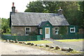
1
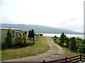
Cottage by Kilbride Lodge
Over the Douglas Water from the caravan park.
Image: © Richard Webb
Taken: 16 Dec 2018
0.00 miles
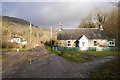
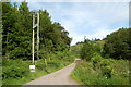
2
Bridge over the Douglas Water
Caravan park on the opposite bank.
Image: © Richard Webb
Taken: 16 Dec 2018
0.02 miles
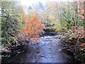
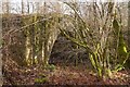
6
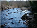
Beside the Douglas Water
An exception to the usually wooded land found along this bit of Loch Fyne.
Image: © Richard Webb
Taken: 16 Dec 2018
0.12 miles
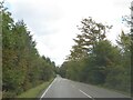
8
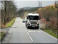
Scania Tanker on the A83
Scania G440 fuel tanker (SL60 JYC) on the A83 near Achnagoul.
Image: © David Dixon
Taken: 25 Mar 2014
0.15 miles