IMAGES TAKEN NEAR TO
INVERARAY, PA32 8XG
Introduction
This page details the photographs taken nearby to PA32 8XG by members of the Geograph project.
The Geograph project started in 2005 with the aim of publishing, organising and preserving representative images for every square kilometre of Great Britain, Ireland and the Isle of Man.

There are currently over 7.5m images from over14,400 individuals and you can help contribute to the project by visiting https://www.geograph.org.uk
Image Map
Images are licensed for reuse under creativecommons.org/licenses/by-sa/2.0
Notes
- Clicking on the map will re-center to the selected point.
- The higher the marker number, the further away the image location is from the centre of the postcode.
Image Listing (6 Images Found)
Images are licensed for reuse under creativecommons.org/licenses/by-sa/2.0
Image
Details
Distance
1
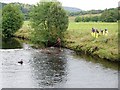
Coastguard rescue exercise
Coastguard crews rehearsing river rescues on the River Aray.
Image: © Patrick Mackie
Taken: 1 Sep 2007
0.06 miles
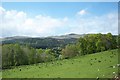
2
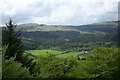
Inveraray Castle
The fields of the home farm seen from Dun na Cuaiche.
Image: © Elliott Simpson
Taken: 6 May 2007
0.18 miles
4
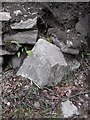
Old Milestone by the A819, north of Inveraray
Stone post by the A819, in parish of Inveraray (Argyll & Bute District), North of Inveraray, in wall, Southwest side of road, 20m North of 'SLOW' on road opposite.
Inscription once read:-
: (Dalmally / 14¾) : : (Inveraray / 1) :
Surveyed
Milestone Society National ID: AB_DLIY15.
Image: © Milestone Society
Taken: Unknown
0.18 miles
5
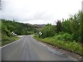
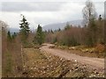
Heading north from Inveraray on the A819
Image: © Elliott Simpson
Taken: 7 Aug 2018
0.20 miles
6
Inveraray Castle Grounds
On the forest walk up to the folly.
Image: © Elliott Simpson
Taken: 6 May 2007
0.25 miles