IMAGES TAKEN NEAR TO
Underwood Road, PAISLEY, PA3 1TL
Introduction
This page details the photographs taken nearby to Underwood Road, PA3 1TL by members of the Geograph project.
The Geograph project started in 2005 with the aim of publishing, organising and preserving representative images for every square kilometre of Great Britain, Ireland and the Isle of Man.

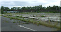
There are currently over 7.5m images from over14,400 individuals and you can help contribute to the project by visiting https://www.geograph.org.uk
Image Map
Images are licensed for reuse under creativecommons.org/licenses/by-sa/2.0
Notes
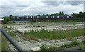
- Clicking on the map will re-center to the selected point.
- The higher the marker number, the further away the image location is from the centre of the postcode.
Image Listing (117 Images Found)
Images are licensed for reuse under creativecommons.org/licenses/by-sa/2.0
Image
Details
Distance
1
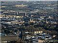
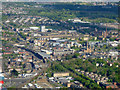
Paisley from the air
Paisley Gilmour Street railway station, the Piazza Centre, town hall, abbey and Mile End Mill are all visible in the centre, with the cleared industrial site at Hawkhead Road beyond. Leverndale Hospital tower is in the top left corner.
Image: © Thomas Nugent
Taken: 28 Jan 2019
0.05 miles
2
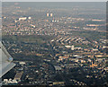
Paisley from the air
Gilmour Street railway station and the town centre are in the foreground, with Glasgow Road, Barshaw park and Hillington in the distance.
Image: © Thomas Nugent
Taken: 18 Mar 2015
0.05 miles
3
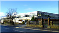
Former Scottish Milk Marketing Board HQ
On Underwood Road, was occupied by Scottish Water for a while, but now appears to be empty.
Image: © Thomas Nugent
Taken: 7 Feb 2011
0.05 miles
4
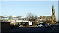
Underwood Road
The former Scottish Milk Marketing Board offices are now shared by First Milk and Scottish Water. St James's church Image] can be seen beyond.
Image: © Thomas Nugent
Taken: 11 Feb 2008
0.05 miles
5
Site of Scottish Milk Marketing Board HQ
The Glasgow to Gourock & Wemyss Bay railway line is now visible since the demolition of the Undwerwood Road buildings.
Image: © Thomas Nugent
Taken: 14 Jun 2013
0.06 miles
6
Site of Scottish Milk Marketing Board HQ
The Glasgow to Gourock & Wemyss Bay railway line is now visible since the demolition of the Undwerwood Road buildings.
Image: © Thomas Nugent
Taken: 14 Jun 2013
0.06 miles
7
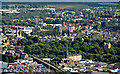
Paisley from the air
St James's church on Underwood Road is in the foreground, with Paisley Gilmour Street railway station just beyond. The Piazza Centre is the prominent striped building near the centre of the photo, with Paisley Abbey, obscured by the town hall, also visible. The tall chimney on the right is at Mile End mill. Glasgow Road can be seen on the right.
Image: © Thomas Nugent
Taken: 15 May 2016
0.06 miles
8
Paisley from the air
Seen just after take-off from Glasgow Airport. The railway line between Paisley St James and Paisley Gilmour Street stations is in the foreground, with St James's Church of Scotland on Underwood Road just beyond. The Town Hall, abbey and the domestic finishing mill in the town centre are all also visible.
Image: © Thomas Nugent
Taken: 7 Aug 2017
0.07 miles
9
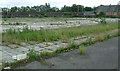
Site of Scottish Milk Marketing Board HQ
The Glasgow to Gourock & Wemyss Bay railway line is now visible since the demolition of the Undwerwood Road buildings.
Image: © Thomas Nugent
Taken: 14 Jun 2013
0.08 miles
10
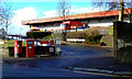
Royal Mail depot
On Underwood Road at Greenhill Road.
Image: © Thomas Nugent
Taken: 7 Feb 2011
0.09 miles