IMAGES TAKEN NEAR TO
Greenhill Road, PAISLEY, PA3 1RN
Introduction
This page details the photographs taken nearby to Greenhill Road, PA3 1RN by members of the Geograph project.
The Geograph project started in 2005 with the aim of publishing, organising and preserving representative images for every square kilometre of Great Britain, Ireland and the Isle of Man.

There are currently over 7.5m images from over14,400 individuals and you can help contribute to the project by visiting https://www.geograph.org.uk
Image Map
Images are licensed for reuse under creativecommons.org/licenses/by-sa/2.0
Notes
- Clicking on the map will re-center to the selected point.
- The higher the marker number, the further away the image location is from the centre of the postcode.
Image Listing (155 Images Found)
Images are licensed for reuse under creativecommons.org/licenses/by-sa/2.0
Image
Details
Distance
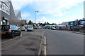
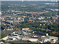
3
Paisley from the air
Greenhill Road and the Royal Mail Depot at Underwood Road are in the foreground. Coats Church tower and the dome at the former John Neilson Institure are also visible. The smaller dome of Coats Observatory is also visible towards the top left. Saucel Hill is in the distance.
Image: © Thomas Nugent
Taken: 7 Aug 2017
0.04 miles
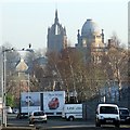
5
Paisley from the air
Gilmour Street railway station is on the left, the Piazza Centre, Abbey and Town Hall are all visible, as are the mills.
Image: © Thomas Nugent
Taken: 22 Apr 2019
0.04 miles
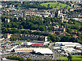
6

Paisley from the air
Looking over Ferguslie Park and to the town centre where St James Church, Gilmour Street railway station, the Piazza Centre, abbey, town hall, Mile End Mill, Domestic Finishing Mill, Embroidery Mill and the Russell Institute can all be seen. The sharp-eyed might also see the dome of Coats Observatory amongst the trees on Oakshaw Hill.
Image: © Thomas Nugent
Taken: 9 Oct 2017
0.04 miles
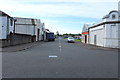
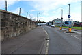
7
Greenhil Road
Image: © Thomas Nugent
Taken: 11 Feb 2008
0.04 miles
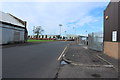
9
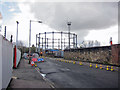
Well Street, Paisley
Some road works are underway. In the background is Number 4 gasholder, built 1890, and a Category A listed structure. It is the oldest surviving column guided gasholder in Scotland and is now a rare survival of its building type.
Image: © Richard Dorrell
Taken: 2 Apr 2019
0.07 miles
