IMAGES TAKEN NEAR TO
Murray Street, PAISLEY, PA3 1QW
Introduction
This page details the photographs taken nearby to Murray Street, PA3 1QW by members of the Geograph project.
The Geograph project started in 2005 with the aim of publishing, organising and preserving representative images for every square kilometre of Great Britain, Ireland and the Isle of Man.

There are currently over 7.5m images from over14,400 individuals and you can help contribute to the project by visiting https://www.geograph.org.uk
Image Map
Images are licensed for reuse under creativecommons.org/licenses/by-sa/2.0
Notes
- Clicking on the map will re-center to the selected point.
- The higher the marker number, the further away the image location is from the centre of the postcode.
Image Listing (176 Images Found)
Images are licensed for reuse under creativecommons.org/licenses/by-sa/2.0
Image
Details
Distance
1
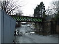
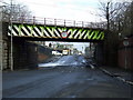
Murray Street
The railway bridge carries the Inverclyde line to Gourock and Wemyss Bay from Paisley Gilmour Street.
Image: © Thomas Nugent
Taken: 19 May 2008
0.01 miles
2
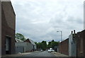
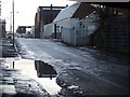
Poor pavement
This is Murray Street, Paisley. The street is within a business area, and not residential, so maintenance of the pavements is not a high priority.
Image: © Richard Dorrell
Taken: 22 Mar 2018
0.02 miles
3
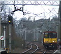
Gourock train at Paisley
Looking towards the centre of Paisley from St James station. See the same train at St James here Image
Image: © Thomas Nugent
Taken: 28 Mar 2008
0.03 miles
4
Low bridge
Carries the Glasgow to Gourock & Wemyss Bay line over a dip in Murray Street. The bridge appears to have been wider in the past. Viewed looking west. See also Image
Image: © Thomas Nugent
Taken: 28 Mar 2008
0.03 miles
5
Low bridge
Carries the Glasgow to Gourock & Wemyss Bay line over a dip in Murray Street. Viewed looking east. See also Image
Image: © Thomas Nugent
Taken: 28 Mar 2008
0.04 miles
6
Murray Street
Flooding is a common occurrence under this railway bridge which carries the Glasgow-Gourock & Wemyss Bay line.
Image: © Thomas Nugent
Taken: 8 Dec 2008
0.05 miles
7
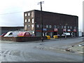
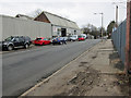
Industrial building on MacKean Street
Viewed from Murray Street.
Image: © Thomas Nugent
Taken: 28 Mar 2008
0.06 miles
8
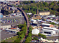
Paisley from the air
The railway is the Inverclyde Line, with part of Paisley St James station visible at the bottom of the photo and part of Gilmour Street station visible to the top. The line is elevated most of the way between the two stations. The prominent church is St James on Underwood Road.
Image: © Thomas Nugent
Taken: 14 May 2018
0.07 miles
9
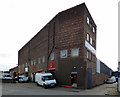
Industrial building on Mackean Street
Possibly a remnant of Murray Street Cooperage https://canmore.org.uk/site/241315/paisley-murray-street-cooperage .
Image: © Thomas Nugent
Taken: 30 Oct 2017
0.08 miles
10
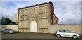
Industrial building on Mackean Street
A remnant of Mackean Street, Retort Works https://canmore.org.uk/site/198366/paisley-mackean-street-retort-works . Still in use as a chemical business under the Wm Tracey Group http://www.williamtraceygroup.com/capabilities/chemical_manufacturing_warehousing .
Image: © Thomas Nugent
Taken: 30 Oct 2017
0.08 miles