IMAGES TAKEN NEAR TO
Tannahill Road, PAISLEY, PA3 1PB
Introduction
This page details the photographs taken nearby to Tannahill Road, PA3 1PB by members of the Geograph project.
The Geograph project started in 2005 with the aim of publishing, organising and preserving representative images for every square kilometre of Great Britain, Ireland and the Isle of Man.

There are currently over 7.5m images from over14,400 individuals and you can help contribute to the project by visiting https://www.geograph.org.uk
Image Map
Images are licensed for reuse under creativecommons.org/licenses/by-sa/2.0
Notes
- Clicking on the map will re-center to the selected point.
- The higher the marker number, the further away the image location is from the centre of the postcode.
Image Listing (151 Images Found)
Images are licensed for reuse under creativecommons.org/licenses/by-sa/2.0
Image
Details
Distance
1
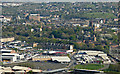
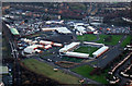
Paisley from the air
St Mirren Park stadium and the Royal Mail depot in the foreground, Oakhill and the town centre beyond.
Image: © Thomas Nugent
Taken: 22 Apr 2019
0.04 miles
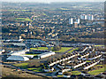
2
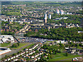
Paisley from the air
Ferguslie Park is in the foreground, with the towerblocks in the south of the town beyond.
Image: © Thomas Nugent
Taken: 15 May 2016
0.06 miles
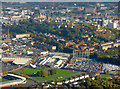
3
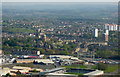
Paisley from the air
St Mirren Park stadium in the foreground, Oakhill and the west end beyond.
Image: © Thomas Nugent
Taken: 22 Apr 2019
0.07 miles
4
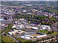
Paisley from the air
St Mirren Park, home of St Mirren FC, recently crowned winners of the Scottish Championship League in 2017-18, is in the foreground.
Image: © Thomas Nugent
Taken: 14 May 2018
0.07 miles
5
St Mirren Park from the air
St Mirren FC moved here from the former St Mirren Park in nearby Love Street in 2009.
Image: © Thomas Nugent
Taken: 23 Jan 2012
0.08 miles
6
St Mirren Park from the air
The 'new' St Mirren Park at Greenhill Road in Ferguslie Park, with Paisley gas works, Coats Church and Saucel Hill beyond.
Image: © Thomas Nugent
Taken: 3 Dec 2018
0.08 miles
7
Paisley from the air
Looking over Ferguslie Park and to the town centre where St James Church, Gilmour Street railway station, the Piazza Centre, abbey, town hall, Mile End Mill, Domestic Finishing Mill, Embroidery Mill, Blackhall Mill, John Neilson Institute, Coats Church and the Russell Institute can all be seen. The sharp-eyed might also see the dome of Coats Observatory amongst the trees on Oakshaw Hill.
Image: © Thomas Nugent
Taken: 9 Oct 2017
0.08 miles
8
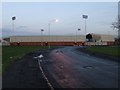
St Mirren's new stadium
Viewed from Drums Crescent.
Image: © Thomas Nugent
Taken: 8 Dec 2008
0.08 miles
9
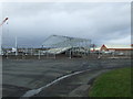
St Mirren's new home takes shape
A great deal of work has been completed in the few weeks since my last visit Image
Image: © Thomas Nugent
Taken: 28 Mar 2008
0.09 miles
10
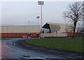
Almost complete
St Mirren's new stadium nears completion. Compare with Image which was taken from the same spot ten months earlier.
Image: © Thomas Nugent
Taken: 8 Dec 2008
0.09 miles