IMAGES TAKEN NEAR TO
Candren Road, PAISLEY, PA3 1DL
Introduction
This page details the photographs taken nearby to Candren Road, PA3 1DL by members of the Geograph project.
The Geograph project started in 2005 with the aim of publishing, organising and preserving representative images for every square kilometre of Great Britain, Ireland and the Isle of Man.

There are currently over 7.5m images from over14,400 individuals and you can help contribute to the project by visiting https://www.geograph.org.uk
Image Map
Images are licensed for reuse under creativecommons.org/licenses/by-sa/2.0
Notes
- Clicking on the map will re-center to the selected point.
- The higher the marker number, the further away the image location is from the centre of the postcode.
Image Listing (13 Images Found)
Images are licensed for reuse under creativecommons.org/licenses/by-sa/2.0
Image
Details
Distance
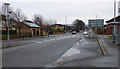
1

Road sign on approach to roundabout
In Ferguslie Park, Paisley.
Image: © Stephen Sweeney
Taken: 3 Jan 2010
0.09 miles
2
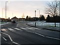
Zebra crossing and roundabout
At Ferguslie Park Avenue.
Image: © Stephen Sweeney
Taken: 3 Jan 2010
0.09 miles
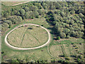
3
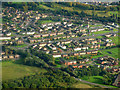
Ferguslie Park from the air
Looking over Barskiven Road towards Ferguslie Park Avenue.
Image: © Thomas Nugent
Taken: 25 Sep 2017
0.12 miles
4

Ferguslie Park from the air
Barskiven Road is in the foreground, with the edge of The Phoenix retail and leisure park in the lower right corner.
Image: © Thomas Nugent
Taken: 3 Dec 2018
0.20 miles
5
Killoch Avenue, Paisley
Modern housing on the edge of Furguslie Park.
Image: © Richard Dorrell
Taken: 2 Apr 2019
0.22 miles
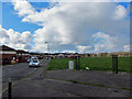
6

Old industrial land from the air
Traces of old railway tracks between Ferguslie and The Phoenix retail park.
Image: © Thomas Nugent
Taken: 24 Sep 2018
0.22 miles
7
Old industrial land from the air
Between Ferguslie Park and the Phoenix retail park.
See the scene in September 2018 Image
Image: © Thomas Nugent
Taken: 15 Jul 2019
0.22 miles
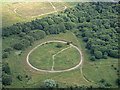
8
Old industrial land from the air
Image: © Thomas Nugent
Taken: 22 Apr 2019
0.22 miles
9
Ferguslie Park Avenue
Looking south from the roundabout at Blackstoun Road.
Image: © Thomas Nugent
Taken: 20 Nov 2016
0.22 miles
10
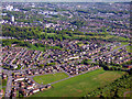
Paisley from the air
The suburb of Ferguslie Park is in the foreground.
Image: © Thomas Nugent
Taken: 14 May 2018
0.23 miles