IMAGES TAKEN NEAR TO
Dalskeith Road, PAISLEY, PA3 1AS
Introduction
This page details the photographs taken nearby to Dalskeith Road, PA3 1AS by members of the Geograph project.
The Geograph project started in 2005 with the aim of publishing, organising and preserving representative images for every square kilometre of Great Britain, Ireland and the Isle of Man.

There are currently over 7.5m images from over14,400 individuals and you can help contribute to the project by visiting https://www.geograph.org.uk
Image Map
Images are licensed for reuse under creativecommons.org/licenses/by-sa/2.0
Notes
- Clicking on the map will re-center to the selected point.
- The higher the marker number, the further away the image location is from the centre of the postcode.
Image Listing (13 Images Found)
Images are licensed for reuse under creativecommons.org/licenses/by-sa/2.0
Image
Details
Distance
1

Road sign on approach to roundabout
In Ferguslie Park, Paisley.
Image: © Stephen Sweeney
Taken: 3 Jan 2010
0.14 miles
2
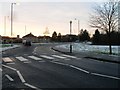
Zebra crossing and roundabout
At Ferguslie Park Avenue.
Image: © Stephen Sweeney
Taken: 3 Jan 2010
0.15 miles
3
Remains of steps
The stairs are at the southern corner of an Image, and they seem to have led into it.
Image: © Lairich Rig
Taken: 7 Jul 2014
0.17 miles
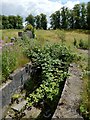
4
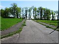
Enclosed space near Ferguslie Gardens
To the left of the wall, the railway line is at the bottom of the slope.
When the first-edition OS map was surveyed, in 1858, this wall had not yet been built, but there was a walled garden not far ahead, part of the estate associated with the now-gone Ferguslie House. At that time, there was railway junction (Linnwood Junction) near here.
When the second edition of the map was surveyed, in about 1895, the junction was gone (there was a single line, as at present), but the wall of the enclosure shown here had been built. At the southern corner (the one from which the picture was taken), there are remains of stairs leading down into it: Image The area enclosed by this wall was probably another part of the gardens associated with Ferguslie House.
Image: © Lairich Rig
Taken: 7 Jul 2014
0.18 miles
5
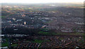
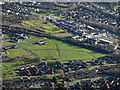
Paisley from the air
Ferguslie Park is in the foreground. The Ayrshire Line railway runs across the bottom of the photo.
Image: © Thomas Nugent
Taken: 23 Jan 2012
0.19 miles
6
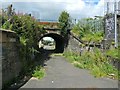
Underpass below railway line
The picture was taken from the Millarstan Avenue side of the line: Image / Image Image shows the underpass from a distance. See Image for the area on the other side of the line.
Image: © Lairich Rig
Taken: 7 Jul 2014
0.21 miles
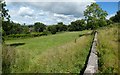
7
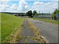
Millarston Avenue
The subject is as in Image, but the view is down rather than up the slope.
Image: © Lairich Rig
Taken: 7 Jul 2014
0.21 miles
10
Paisley from the air
The railway line from Glasgow to Ayr separates Ferguslie in the foreground from Millarston.
Image: © Thomas Nugent
Taken: 28 Jan 2019
0.22 miles