IMAGES TAKEN NEAR TO
LOCHGILPHEAD, PA31 8RY
Introduction
This page details the photographs taken nearby to PA31 8RY by members of the Geograph project.
The Geograph project started in 2005 with the aim of publishing, organising and preserving representative images for every square kilometre of Great Britain, Ireland and the Isle of Man.

There are currently over 7.5m images from over14,400 individuals and you can help contribute to the project by visiting https://www.geograph.org.uk
Image Map
Images are licensed for reuse under creativecommons.org/licenses/by-sa/2.0
Notes
- Clicking on the map will re-center to the selected point.
- The higher the marker number, the further away the image location is from the centre of the postcode.
Image Listing (5 Images Found)
Images are licensed for reuse under creativecommons.org/licenses/by-sa/2.0
Image
Details
Distance
1
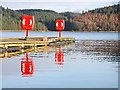
Well-protected pontoon jetty
Access to the second lifebuoy is somewhat restricted by the first.
Image: © Patrick Mackie
Taken: 19 Dec 2006
0.06 miles
2
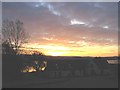
Sunrise over Achnaba Cottages by the A83.
Image: © Johnny Durnan
Taken: 19 Nov 2005
0.08 miles
3
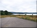
Looking across Port Ann bay to Glas Eilean
Image: © Elliott Simpson
Taken: 8 Aug 2013
0.15 miles
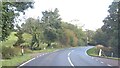
5
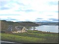
Achnaba Cottages overlooking Loch Fyne.
Image: © Johnny Durnan
Taken: 3 Dec 2005
0.16 miles