IMAGES TAKEN NEAR TO
Castle Gardens, PAISLEY, PA2 9RA
Introduction
This page details the photographs taken nearby to Castle Gardens, PA2 9RA by members of the Geograph project.
The Geograph project started in 2005 with the aim of publishing, organising and preserving representative images for every square kilometre of Great Britain, Ireland and the Isle of Man.

There are currently over 7.5m images from over14,400 individuals and you can help contribute to the project by visiting https://www.geograph.org.uk
Image Map
Images are licensed for reuse under creativecommons.org/licenses/by-sa/2.0
Notes
- Clicking on the map will re-center to the selected point.
- The higher the marker number, the further away the image location is from the centre of the postcode.
Image Listing (31 Images Found)
Images are licensed for reuse under creativecommons.org/licenses/by-sa/2.0
Image
Details
Distance
1
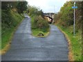
Cycle route near Meikleriggs
Here, routes NCN7 and NCN75 follow the former course of a railway line; for more information, see Image, which was taken only a short distance further east on the same route.
In the late nineteenth century, the bridge that is visible not far ahead carried Green Road over the railway line; the present-day road retains that name.
Image: © Lairich Rig
Taken: 7 Oct 2010
0.09 miles
2
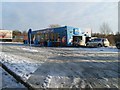
Arc Car Wash, Millarston, Paisley
Note the queue of traffic waiting to use it - as a driver who has been trying to wash my car for several days I sympathise with them, havin been turned away from no less than five car washes which were out of operation due to the systems being frozen over in these conditions.
Image: © Stephen Sweeney
Taken: 3 Jan 2010
0.15 miles
3
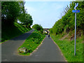
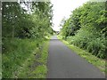
National Cycle Network Route 7
The bridge carries Green Road over the path.
Image: © Thomas Nugent
Taken: 29 Apr 2011
0.15 miles
4
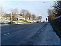
Ferguslie
Main road into Millarston in the west of Paisley. Unusual in that it is a dual carriageway with no central island.
Image: © Stephen Sweeney
Taken: 3 Jan 2010
0.17 miles
5
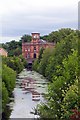
Ferguslie Thread Mills, Paisley, Scotland
Bridge Lane Gate House, now converted to residential flats.
Image: © Robert Sweeney
Taken: 10 Jul 2005
0.17 miles
6
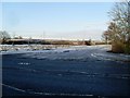
Waste ground, Millarston
Perhaps something will become of it when the area is redeveloped in the near future.
Image: © Stephen Sweeney
Taken: 3 Jan 2010
0.19 miles
7
Paisley Canal Line
This railway is still in use between Glasgow and Paisley. After Paisley it is a cycle path, carrying National Cycle Route 7 and 75 between Paisley and Johnstone.
Image: © Richard Webb
Taken: 22 Jun 2009
0.19 miles
8
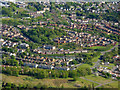
Paisley from the air
Looking over Millarston towards the south of Paisley. The remains of the Glasgow and Ardrossan Canal can be seen in the foreground.
Image: © Thomas Nugent
Taken: 15 May 2016
0.19 miles
9

Site of redevelopment, Millarston, Paisley
Recently demolished houses by Ferguslie. The sign proclaims that plans for the area will be revealed soon.
Image: © Stephen Sweeney
Taken: 3 Jan 2010
0.19 miles
10
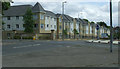
Ferguslie
Flats on the site of John Neilson High School.
Image: © Thomas Nugent
Taken: 14 Jun 2013
0.20 miles