IMAGES TAKEN NEAR TO
Jedburgh Drive, PAISLEY, PA2 9JH
Introduction
This page details the photographs taken nearby to Jedburgh Drive, PA2 9JH by members of the Geograph project.
The Geograph project started in 2005 with the aim of publishing, organising and preserving representative images for every square kilometre of Great Britain, Ireland and the Isle of Man.

There are currently over 7.5m images from over14,400 individuals and you can help contribute to the project by visiting https://www.geograph.org.uk
Image Map
Images are licensed for reuse under creativecommons.org/licenses/by-sa/2.0
Notes
- Clicking on the map will re-center to the selected point.
- The higher the marker number, the further away the image location is from the centre of the postcode.
Image Listing (10 Images Found)
Images are licensed for reuse under creativecommons.org/licenses/by-sa/2.0
Image
Details
Distance
2
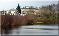
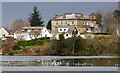
Stanely Reservoir and Stanely House
The house is Category B Listed http://portal.historicenvironment.scot/designation/LB39117 . Now home to a Christian youth group, Youth With A Mission http://ywamstanely.org/#after_section_1 .
Image: © Thomas Nugent
Taken: 29 Feb 2016
0.21 miles
3
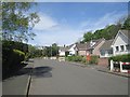
Suburban Paisley
Stanely Avenue, to the south of the city centre.
Image: © Richard Webb
Taken: 21 May 2013
0.22 miles
4
Stanely Reservoir and Castle
The ruined early 15th Century castle is at the west end of the reservoir and is surrounded by water which covers the ground floor.
Image: © Thomas Nugent
Taken: 29 Feb 2016
0.23 miles
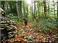
5
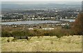
Stanely Reservoir
The reservoir was built in 1837 by the Paisley Water Company to provide drinking-water to Paisley. Seen from Gleniffer Braes Country Park.
Image: © Richard Sutcliffe
Taken: 23 Feb 2023
0.23 miles
6
Stanely Reservoir and Stanely House
The house is Category B Listed http://portal.historicenvironment.scot/designation/LB39117 . Now home to a Christian youth group, Youth With A Mission http://ywamstanely.org/#after_section_1 .
Image: © Thomas Nugent
Taken: 29 Feb 2016
0.23 miles
7
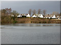
Stanely Reservoir
The smaller of the two reservoirs. The houses are on Stanely Crescent.
Image: © Thomas Nugent
Taken: 29 Feb 2016
0.23 miles
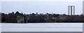
8
Glennifer High School and Stanely Reservoir from the air
The school is on Amochrie Road http://www.glenifferhigh.renfrewshire.sch.uk/ . The towerblocks are Glennifer Court (left) and Nethercraigs Court.
Image: © Thomas Nugent
Taken: 15 May 2016
0.24 miles
9
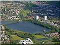
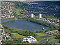
Glennifer High School and Stanely Reservoir from the air
The school is on Amochrie Road http://www.glenifferhigh.renfrewshire.sch.uk/ . The towerblocks are Glennifer Court (left) and Nethercraigs Court. Glenburn Road can be seen beyond the reservoir, with Glenburn on its left.
Image: © Thomas Nugent
Taken: 15 May 2016
0.24 miles
10
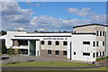
Gleniffer High School, Amochrie Road, Paisley
Image: © Leslie Barrie
Taken: 9 Jul 2014
0.25 miles