IMAGES TAKEN NEAR TO
Cardell Avenue, PAISLEY, PA2 9EJ
Introduction
This page details the photographs taken nearby to Cardell Avenue, PA2 9EJ by members of the Geograph project.
The Geograph project started in 2005 with the aim of publishing, organising and preserving representative images for every square kilometre of Great Britain, Ireland and the Isle of Man.

There are currently over 7.5m images from over14,400 individuals and you can help contribute to the project by visiting https://www.geograph.org.uk
Image Map
Images are licensed for reuse under creativecommons.org/licenses/by-sa/2.0
Notes
- Clicking on the map will re-center to the selected point.
- The higher the marker number, the further away the image location is from the centre of the postcode.
Image Listing (9 Images Found)
Images are licensed for reuse under creativecommons.org/licenses/by-sa/2.0
Image
Details
Distance
1
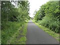
Paisley Canal Line
This railway is still in use between Glasgow and Paisley. After Paisley it is a cycle path, carrying National Cycle Route 7 and 75 between Paisley and Johnstone.
Image: © Richard Webb
Taken: 22 Jun 2009
0.09 miles
2
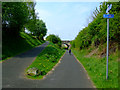
National Cycle Network Route 7
The bridge carries Green Road over the path.
Image: © Thomas Nugent
Taken: 29 Apr 2011
0.11 miles
3
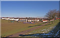
Recreation Ground, Brediland, Paisley
View from Morar Road looking towards Cardell Road.
Image: © wfmillar
Taken: 2 Mar 2010
0.13 miles
4
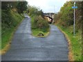
Cycle route near Meikleriggs
Here, routes NCN7 and NCN75 follow the former course of a railway line; for more information, see Image, which was taken only a short distance further east on the same route.
In the late nineteenth century, the bridge that is visible not far ahead carried Green Road over the railway line; the present-day road retains that name.
Image: © Lairich Rig
Taken: 7 Oct 2010
0.15 miles
5
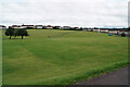
Recreation ground
A large open area, viewed here looking north from Morar Drive.
Image: © Richard Dorrell
Taken: 10 Aug 2021
0.16 miles
6
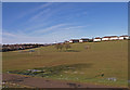
Recreation Ground, Brediland, Paisley
Looking over the playing field towards Millarston. The snow in the distance is lying on Muirshiel Hills.
Image: © wfmillar
Taken: 2 Mar 2010
0.16 miles
7
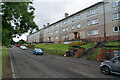
Morar Drive, Paisley
The flats here have an impressive view over a large recreation ground.
Image: © Richard Dorrell
Taken: 10 Aug 2021
0.17 miles
8
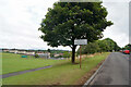
Morar Drive, Paisley
A pre-Worboys road sign warns drivers to take care on this road which borders a large recreation ground.
Image: © Richard Dorrell
Taken: 10 Aug 2021
0.17 miles
9
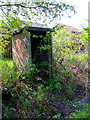
old railway hut by National Cycle Network Route 7
Behind the houses on Lounsdale Avenue.
Image: © Thomas Nugent
Taken: 29 Apr 2011
0.17 miles