IMAGES TAKEN NEAR TO
Weavers Road, PAISLEY, PA2 9DP
Introduction
This page details the photographs taken nearby to Weavers Road, PA2 9DP by members of the Geograph project.
The Geograph project started in 2005 with the aim of publishing, organising and preserving representative images for every square kilometre of Great Britain, Ireland and the Isle of Man.

There are currently over 7.5m images from over14,400 individuals and you can help contribute to the project by visiting https://www.geograph.org.uk
Image Map
Images are licensed for reuse under creativecommons.org/licenses/by-sa/2.0
Notes
- Clicking on the map will re-center to the selected point.
- The higher the marker number, the further away the image location is from the centre of the postcode.
Image Listing (39 Images Found)
Images are licensed for reuse under creativecommons.org/licenses/by-sa/2.0
Image
Details
Distance
1
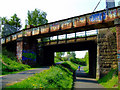
National Cycle Route at Paisley
A pair of rusty old bridges near Green Road. See also Image
Image: © Thomas Nugent
Taken: 29 Apr 2011
0.07 miles
2
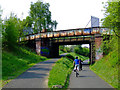
National Cycle Network Route 7
A pair of rusty old bridges near Green Road. See also Image
Image: © Thomas Nugent
Taken: 29 Apr 2011
0.07 miles
3
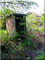
old railway hut by National Cycle Network Route 7
Behind the houses on Lounsdale Avenue.
Image: © Thomas Nugent
Taken: 29 Apr 2011
0.08 miles
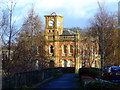
4
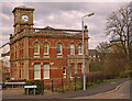
Bridge Lane Gate House, Paisley
Now converted to residential flats. Originally part of Ferguslie Thread Mills. Maxwellton flats in the background (right).
Image: © wfmillar
Taken: 28 Mar 2011
0.15 miles
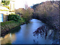
5
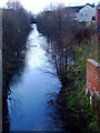
Glasgow and Ardrossan Canal
Looking along the remains of the canal from the bridge at the Bridge lane gatehouse.
See also Image
Image: © Thomas Nugent
Taken: 7 Feb 2011
0.15 miles
6
Bridge Lane Gatehouse
The gatehouse is now converted to flats. It straddles part of the disused Glasgow and Ardrossan canal, which runs behind the railings on the left. Viewed from Tenters Way.
Image: © Thomas Nugent
Taken: 7 Feb 2011
0.15 miles
7
Bridge Lane Gatehouse
One of the gatehouses at the former Ferguslie Mill complex, now converted to flats. The remains of the former Glasgow and Ardrossan canal can be seen.
See also Image
Image: © Thomas Nugent
Taken: 7 Feb 2011
0.15 miles
8
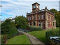
Bridge Lane Gatehouse
The former Bridge Lane Gatehouse dates from 1887 and was part of the Ferguslie Thread Works. It is depicted in other contributors' earlier pictures: Image / Image / Image / Image
On the left, a footbridge takes the path over the old Paisley Canal.
Compare Image, a different building not far away.
Image: © Lairich Rig
Taken: 14 Sep 2017
0.15 miles
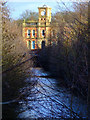
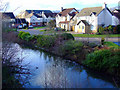
9
Glasgow and Ardrossan Canal
Very little remains of the canal today. This stretch at the former Ferguslie Mill is now part of a housing development. The rear of the former Counting House is on the left Image
Image: © Thomas Nugent
Taken: 7 Feb 2011
0.16 miles
10
Arkwrights Way
A new housing development by the former Glasgow and Ardrossan canal on the site of the former Ferguslie Mill.
Image: © Thomas Nugent
Taken: 7 Feb 2011
0.17 miles