IMAGES TAKEN NEAR TO
PAISLEY, PA2 8UT
Introduction
This page details the photographs taken nearby to PA2 8UT by members of the Geograph project.
The Geograph project started in 2005 with the aim of publishing, organising and preserving representative images for every square kilometre of Great Britain, Ireland and the Isle of Man.

There are currently over 7.5m images from over14,400 individuals and you can help contribute to the project by visiting https://www.geograph.org.uk
Image Map
Images are licensed for reuse under creativecommons.org/licenses/by-sa/2.0
Notes
- Clicking on the map will re-center to the selected point.
- The higher the marker number, the further away the image location is from the centre of the postcode.
Image Listing (6 Images Found)
Images are licensed for reuse under creativecommons.org/licenses/by-sa/2.0
Image
Details
Distance
2
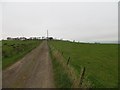
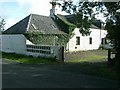
Road, Mountop
Farm driveway above Johnstone.
Image: © Richard Webb
Taken: 25 Apr 2014
0.10 miles
3
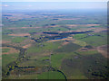
Auchengreoch Road from the air
Look closely in the top left corner to see the hundreds of wind turbines at Whitelee Moor.
Image: © Thomas Nugent
Taken: 14 May 2018
0.17 miles
4
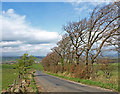
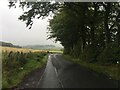
Auchengreoch Road
This country road takes you from Spateston near Johnstone up to the Gleniffer Braes. You can see by the trees this is a windswept part of the country.
Image: © wfmillar
Taken: 22 Apr 2009
0.17 miles
5
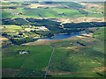
Caplaw Dam from the air
Lapwing Lodge outdoor centre (Scouts) http://www.lapwinglodge.org.uk/ is amongst the trees.
Image: © Thomas Nugent
Taken: 15 May 2016
0.22 miles